


NASA DEVELOP is part of NASA’s Applied Sciences Program, and addresses environmental and public policy issues through interdisciplinary research projects that apply the lens of NASA Earth observations to community concerns around the globe. Bridging the gap between NASA Earth Science and society, DEVELOP builds capacity in both participants and partner organizations to better prepare them to address the challenges that face our society and future generations. The NASA DEVELOP program at CSU, in partnership with USGS, has led three NASA DEVELOP projects with a focus on Ethiopia to date.
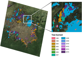
The Bale-Arsi massif of south-central Ethiopia comprises one of the largest and least studied mountain systems in Africa. An internationally recognized biodiversity hotspot, the region is home to Bale Mountains National Park and the Sanetti Plateau, which provide critical alpine habitat for numerous endemic and endangered species such as the Mountain Nyala. Ethiopian agro-pastoralists in the region practice intentional burning to clear land for grazing and planting; however, pressures related to climate change and increasing populations have made understanding the frequency and extent of burning a top data need for conservationists and park managers seeking to balance conservation goals with the needs of local communities. We quantified historical fire occurrence and extent in the unique, high-altitude Ericaceous shrublands of Bale, using 42 years (1973-2015) of Landsat data. Multispectral images were spatially and spectrally linked within the LandsatLinkr R package, masked for clouds using a 30 m Shuttle Radar Topography Mission (SRTM) digital elevation model, and subsequently analyzed using the LandTrendr disturbance algorithm. The resulting fire extents were validated using the Moderate Resolution Imaging Spectroradiometer (MODIS) Burned Area product, as well as ancillary field records compiled from the literature. Maps and spatial data of fire date and extent were disseminated to project partners working in Bale. These will enable targeted conservation efforts in the park, and inform management approaches that ensure the preservation of the region's natural resources and the social-ecological systems they support. The Earthzine video of this project can be found here.
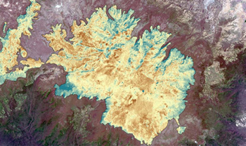
The Bale Mountains of south-central Ethiopia comprise one of Africa’s least-studied massifs, and are home to the world-renowned Bale Mountain National Park. A designated Biodiversity Hotspot, the area also serves as the headwaters for five major rivers that flow out of the mountains, supporting 12 million people in the arid lowlands to the east. In recent years, development in the surrounding area has forced many agro-pastoralists into the highlands, and approximately 40,000 people now live within the park boundaries. Mapping the location and extent of the region’s water resources has been identified as a key research need for local park officials and conservation groups as they work to sustainably accommodate this massive influx of people and livestock. Of particular concern are the region’s numerous alpine lakes and wetlands, as they are essential for wildlife habitat, water quality, and discharge timing for both upstream and downstream users throughout the dry season. This study used environmental indices derived from Landsat 8 Operational Land Imager/Thermal Infrared data, topographic variables, and species distribution models to map all perennial alpine lakes and wetlands in the Bale Mountains. Resulting models of wetlands and lakes had classification accuracies of 97% and 100%, respectively. These represent the first comprehensive maps of their kind in Bale, and will facilitate the targeting of conservation and research efforts in the region. Additionally, the methodology is applicable in other remote areas around the world where field data is sparse and regular monitoring is needed. The Earthzine video of this project can be found here.
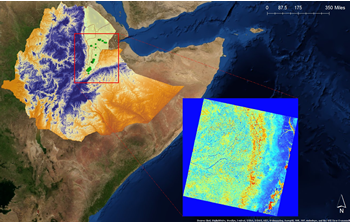
Invasion of non-native species is among the most critical threats to natural ecosystems and economies globally. Mesquite, which includes some 45 species of invasive deciduous trees and shrubs, are known to have an array of negative impacts on ecosystems and rural livelihoods in arid and semi-arid regions around the world, dominating millions of hectares of land in Asia, Africa, Australia and the Americas. In Ethiopia, Prosopis juliflora (the only reported mesquite) is viewed as the most problematic plant invader to the country and, due to its rapid spread and persistence, has been ranked as one of the leading threats to traditional land use. Community concerns regarding mesquite are tied to local economic practices, water access, and habitat degradation, as the invader threatens crop and range production, desiccates limited water resources, and displaces native flora and fauna. This project utilized moderate resolution (30 meter) Landsat 8 data and species distribution modeling to map current infestations of P. juliflora in the Afar region of northeastern Ethiopia. Additionally, a forecast model of P. juliflora habitat suitability was developed for the entire country of Ethiopia using climatic and topographic data. The current model revealed 110,761 hectares of land within the study region to be infested by P. juliflora, and further showed additional occurrences of mesquite in areas of Afar that have not been surveyed to date. Moreover, the national forecast model predicted suitable habitat across the Afar and the Somali regions of Ethiopia, highlighting the increased invasion risk faced by these ecologically similar landscapes. This work lends evidence to the enhanced accuracy provided by remotely sensed indices when mapping invasive mesquite and the utility such approaches hold as decision-support tools for local land managers and pastoral communities to address mesquite invasion. The Earthzine video of this project can be found here and an Amharic version of the video can be found here.
For more information on these projects, contact Paul Evangelista at paul.evangelista@ColoState.EDU.