![]()
![]()
|
||||
| The
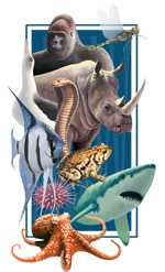
Animal Diversity Web is an online database of animal natural history,
distribution, classification, and conservation biology at the University
of Michigan. The database has thousands of species accounts about
individual animal species written by college students. These may
include text, pictures of living animals, photographs and movies
of museum specimens, and/or recordings of sounds. Professional biologists
have prepared the descriptions of levels of organization above the
species level, especially phyla, classes, and in some cases, orders
and families. Hundreds of hyper-linked pages and images illustrate
the traits and general biology of these groups. These pages are
particularly useful for training advanced undergraduates and graduate
students. The site is used as a biodiversity encyclopedia for students and the general public. It is a teaching resource that uses the inherent draw of animals to lead college students to learn about the scientific method and writing. Also, it is a virtual museum, providing a public window to zoological resources available in research museums. |
 |
During the IBOY, the project plans to structure the information in a way that maximizes learning possibilities by increasing the size of the database, redesigning pages to better accommodate invertebrates, adding descriptions of most major taxonomic groups, and improving assistance to the media with maps and videos of animal behavior generated by scientists. Also expected of the project is a research study on the project’s activities in undergraduate science education.
This fall, the project will also launch a pilot curriculum for 5th and 6th graders called BioKIDS: Kids Inquiry of Diverse Species in collaboration with the OneSky team at the School of Education at University of Michigan and the NatureMapping program at University of Washington. Their observations will contribute to maps used by scientists. The curriculum will involve field trips that lead young students to explore their local wildlife and learn how they differ from other ecosystems allowing them to become more aware of worldwide biodiversity issues. BioKIDS will become self-sustaining after five years. More schools and the complete curriculum will be tested further in Spring 2002.
-- Philip Myers and Cynthia Sims Parr
Biodiversity Portrait of the St. Lawrence (website)
Treed swamps, marshes and reed-beds are important nesting habitats for wetland and aquatic birds. The aerial extent of these types of habitat during spring floods along the St. Lawrence, together with their floristic components, are largely related to the cyclic fluctuation in water levels in the freshwater part of the river. Little quantitative information is available on the response of wetland birds to the change in their breeding habitats. This project is aimed at studying this aspect by using surveys of birds and their wetland habitats along the freshwater section of the St. Lawrence. By characterizing the main wetland bird communities on the basis of the botanical characteristics of their nesting habitats, the project leaders hope to be able to develop a classification system for wildlife habitats that can be used to produce thematic maps (bird communities and biodiversity) for the St. Lawrence as a whole. Another aim is to identify areas that should be conserved on a priority basis along the river, along with any rare and threatened bird communities and species that may be located there.
Half of the priority sites for biodiversity conservation along the St. Lawrence are located in the freshwater section of the river, and 20% of these sites do not have any kind of protected status.
Canadian Biodiversity Information Network (website)
The Canadian Biodiversity Information Network (CBIN) contains links to information, publications, policy, services and many other biodiversity-related sites in a wide range of sectors, including forestry, agriculture, marine and coastal ecosystems, freshwater, indigenous knowledge, and more. It provides access to a "network of networks" leading users quickly to their desired destination, through a simple search/result interface.
In addition, CBIN contains a list of international convention documents, Canadian policies and reports, and provides tools to access and search them. It contains a historical background to the Convention and Canada’s involvement, as well as quick access to each of the sector networks.
CBIN also assist in notifying biodiversity practitioners and the general public on activities related to biodiversity events, publications and policy developments in Canada.
CBIN aims to provide one-window access to Biodiversity information across Canada. The Biodiversity Convention Office of Environment Canada, in cooperation with its partners, created CBIN in order to fulfill Canada’s responsibility to the United Nations Convention on Biological Diversity (CBD). The Canadian web site represents one of many national nodes on the international Clearing-house Mechanism of the CBD and it serves both Canada and a broader global audience.
Central Coast Flora Project (CENCO)
The Central Coast Flora Project (CENCO) documents the distribution of plant taxa from Monterey and San Benito counties south to Ventura County, and the eight California Channel Islands. This region is known to include about 600 of California's rarest plants and large areas of relatively undisturbed natural vegetation. The purpose of the project is to accurately portray the distribution of plants for the purposes of floristic analysis and long-term management of rare plants and natural vegetation. Documentation is based on herbarium specimens and authoritative peer-reviewed literature. The project uses a relational database, coordinated with a geographical information system. Locality data is classified into sub-regions (e.g., Santa Lucia Mountains, Santa Cruz Island) and specific management units (e.g., Ventura County, Los Padres National Forest). The database also includes references to pertinent literature.
The Crosby Arboretum, Mississippi State University Extension (website)
The Crosby Arboretum is planning a series of biodiversity education activities for the general public during 2001-2002 to celebrate the IBOY. Click here for more information on the Arboretum’s activities in 2002.
The Crosby Arboretum is dedicated to the preservation, conservation and education of the natural and cultural history of the Gulf Piney Woods ecosystem. The Arboretum is comprised of nearly 1,000 acres of natural areas selected for their biological value of varying plant communities. Pitcher plant bogs, longleaf pine forests, bottomland hardwoods, sweetbay-tupelo-swampbay, beech-magnolia, and other forest types are being preserved, managed and utilized for research. Pinecote, the Crosby Arboretum’s 104-acre public Interpretive Center, is located in Picayune, Mississippi. The Center is open full-time to public visitation and displays natural and restored plant communities indigenous to the Gulf Coast. Tours, lectures, workshops and programs are offered throughout the year for various topics concerning the local ecosystems. For more information, call (+1) 601 779 2311.
Images produced by Publishing Center for Cultural Resources, NYC and the Crosby Arboretum Foundation:
Ecoparque – An environMENTAL Production (website)
"Ecoparque" illustrates the flourishing biodiversity of a community-based park in Tijuana, Baja California that, due to an innovative system of treating and irrigating with local human wastewater, has grown on a formerly barren hillside dumpsite. The biofiltration system mimics nature to derive safe, odor-free, nutrient-rich water and compost that allows lush native flora and fauna to thrive. The park has become an ecological education center for students of all levels and community residents. A rare green area that provides wildlife refuge, peace, quiet, and shade in paved-over, desert Tijuana, the park has attracted people as well as civic infrastructure, raising the local standard of living. Further, for each neighborhood-scale treatment facility and park such as the one explored in "Ecoparque," less sewage needs to be released into the coastal waters via a centralized conveyance system. Furthermore, beyond these benefits to biodiversity and human health, "Ecoparque" also showcases this zero-waste method of wastewater management as an affordable and viable option for residential settlements currently without wastewater infrastructure, forced to pollute wild canyons.
This video has been met with enthusiastic reception from students, educators, policy-analysts, and decision makers across the world. Winning Honorable Mention in the EarthVision 2001, "Ecoparque" has been acquired by hundreds of schools, institutes, and interested individuals, and incorporated into curricula. It has been screened in dozens of film venues across California and the U.S.-Mexico border region, as well as featured at the 2000 Conference of the National Hispanic Environmental Council in Denver, CO. "Ecoparque" has been broadcast on Del Mar Television, Santa Cruz Community Television, and Student-Run Television of the University of California, in San Diego. More public response and history can be found on the website.
In order to make this and similar natural methods for conservation better-known, we are continuing to book screenings and discussions with scholarly and creative-endeavor institutes, such as upcoming events with the Institute for the Americas, Center for U.S.-Mexico Studies, and the performance organization Lower Left. A completely Spanish version of "Ecoparque" was released at the end of 2001, opening a tremendous additional potential audience to the message contained in "Ecoparque."
“Ecoparque” is an educational product distributed by environMENTAL Productions, whose mission is to capture and communicate the way people interact with the environment and with each other.
ENV200Y: Assessing Global Change (website)
ENV200Y, a course offered at the University of Toronto, will focus this year on climate change and biodiversity. This environment course is specifically designed to fill the science literacy requirement of humanities, social science and commerce students. The aim of this project is to better students’ knowledge on issues in modern science with the aid of tutorials, and hands-on experience such as:
This Spring 2002, students are "Evaluating the State of the North American Environment." The students are working through the Council on Environment Cooperation's Report (CEC), "The North American Mosaic" and will critique the CEC's assessment against the Environmental Sustainability Index (ESI) proposed at the Davos meetings in 2001 by a group from Yale and Columbia Universities. Additional information can be found at http://www.cquest.utoronto.ca/env/env200y/ESSAY02/index.html
Landscape Linkages to Spatial Patterns in the Diversity of Fishes - A Key for Planning Marine Reserves (website)
This project is collecting and analyzing data from fish censuses conducted with remotely operated vehicles (ROVs) to help design marine reserves. It is providing information on the distribution and abundance of fish at a variety of spatial scales and in a variety of habitats, in order to develop predictive models to determine the size ranges of potential marine reserves needed to encompass the diversity of resident fishes.
Interest in designating areas of the ocean as marine reserves has increased in the last decade. This is due in part to the effects of expanding coastal development, runoff from contaminants, and extreme declines in exploited fish populations with concomitant effects due to by-catch and habitat alterations. Together all of these human caused disturbances have resulted in significant alterations in ocean ecosystems and patterns of biological diversity. Species once thought in endless supply are now considered threatened with extinction.
A significant issue, from both a scientific and societal perspective, is how to plan for systems of marine reserves in regions where humans can only see the surface of the ocean. The two major questions are: (1) where should reserves be located, and (2) how large should they be? To answer these questions we must first know what data are available and what approaches can be used to develop sets of alternative sites. Since most developed nations have good data on the distribution and abundance of continental shelf fishes, data on biodiversity of fishes may prove to be an excellent tool for development of marine reserves. However, we need to know whether fish can be used as proxies for patterns of biological diversity of other taxa or habitats. This project uses data on the distribution and abundance of continental fishes off the northeastern United States, at both regional and local scales, to address these issues. It aims to serve as a model for addressing such issues in other parts of the world.
Previous work in this study has identified large-scale, bioregional boundaries for fishes using multivariate statistical techniques. It has shown that shallow and deep water fish communities are consistent from year to year and are correlated with depth and temperature. Boundaries plotted for shallow and deep water communities varied somewhat but generally defined Georges Bank and the rim of the Gulf of Maine as a shallow water community, and the deep basins of the Gulf as a deep water community. The sampling units for these large-scale, regional analyses consisted of single trawls (1.8nm distance) and yield a spatial resolution that may be too coarse for predicting areas needed for lasting protection. Information is needed at smaller spatial-scales to assess how the factors that constrain the distribution of fish act on other taxa, such as motile and sessile invertebrates that have lower movement rates than fish. While oceanographic conditions constrain large scale distributions of fishes, sediment type and landscape features constrain both fish and invertebrates at smaller scales. Data collected at smaller spatial scales, using fish community distributions as boundaries, will enable areas of greatest habitat heterogeneity to be identified that potentially contain the greatest diversity of fishes and invertebrates and can be targets for conservation attention.
Ongoing research is using video census techniques from ROVs to develop species-area and species-individual curves for fishes in different landscape units to predict the minimum size of an area required to contain the suite of resident species. During IBOY, the specific research goals of the project are to:
The project’s products will include:
It is important to realize that systematic approaches are only a starting point for discussing the utility of marine reserves as a conservation tool. Socio-economic considerations and other constraints may ultimately determine where protected areas are initially placed. However, once some distinct areas are protected, further research can determine what was missed and apply such knowledge to future decision-making. Designating the first marine reserves will be an experiment to some extent and research to determine the performance of such sites will be critical for understanding their full value.
-- Peter Auster
Molecular Studies of Marine Biodiversity (MSMB) on the Indian River Lagoon, Florida and Andros Island, Bahamas
This upper level college course is currently offered through Harbor Branch Oceanographic Institution, the Bahamas Environmental Research Center (BERC) and affiliate colleges - Florida Institute of Technology (Melbourne, FL) and the College of the Bahamas (Nassau) every second summer. The primary instructor is Dr. Jose V. Lopez. The course is open to senior undergraduate and graduate students and aims to convey fundamental theory, laboratory and in situ principles associated with genetic variation, the foundation of all biological diversity. Classroom lectures center on the broad disciplines of evolutionary biology, molecular genetics, population genetics, and the burgeoning fields of bioinformatics and genomics. Implications of genetic variation assessments for species evolution, bioprospecting and conservation policy are also explored. Laboratory experiences include practical exercises with macromolecular sequences and databases (e.g. GenBank) and wet lab molecular protocols such as tissue preservation and DNA extraction of various marine invertebrates, the PCR (Polymerase Chain Reaction), AFLP (amplified fragment length polymorphisms) and ISSR (interspersed simple sequence repeat - e.g. microsatellite) DNA fingerprinting. Set up of a "Mobile Molecular Laboratory" (MJ Research) at BERC allows completion of experiments from the sample collection stage to final analyses by gel electrophoresis. Students in the past have originated from various states and countries (Mexico, Australia and Venezuela) have focused on genetic variation within various marine invertebrate and plant organisms. For example, recent application of ISSR fingerprinting on Aplysina marine sponges suggested intraspecific population differentiation on Andros island coral reefs, whereas AFLP analyses on the threatened Queen conch (Strombus gigas) yielded opposite results. Field trips to the lush tropical habitats found at both Florida and Andros island locales - mangrove swamps, blue holes, and coral reefs - are scheduled alongside cultural interactions with Andros Island residents at Staniard Creek and other human settlements.
This course is seeking additional funding to subsidize and lower tuition costs for students to attend the course. Interested parties should contact Dr. Jose Lopez.
For more information on this course visit the following links:
National Biological Information Infrastructure (NBII) (website)
The National Biological Information Infrastructure (NBII) was launched following a National Research Council report in November 1993 that recommended establishing a national partnership for sharing information about the United States’ biological resources. The NBII strives to advance technological capacity for the storage, exchange, standardization and dissemination of biological information, and to provide an Internet gateway through which users can quickly and efficiently gather data and information on the nation's plants and animals. NBII customers include resource managers, scientists, educators, and the general public.
NBII activities begin with the recognition that biodiversity information takes many forms: from biological specimens gathered by early explorers of the United States, to up-to-the-minute environmental data collected from Earth-orbiting satellites. This immensely valuable and varied information can be found in paper files, publications, and computers of government agencies and private organizations, and in universities, libraries, and museums nationwide. The NBII is dedicated to acquiring and integrating different types of information originating from multiple sources. The challenge of bringing together and making available a wide range of biodiversity information is being met by new information products, technical standards, and analytical tools developed and maintained by the NBII and its partners in government agencies (federal, state, and local), academic institutions, non-government organizations, natural history museums and private industry.
In the IBOY year of 2001-2002, the NBII is significantly expanding its activities. For FY2001, Congress approved a $4 million increase in the NBII to support data collection and integration activities in six geographic regions, and for two important subject areas, fisheries and migratory birds. Work is now under way to develop these and other regional and thematic NBII entry points, or "nodes," that will form the "next generation" NBII. This work follows from a recommendation by the President's Committee of Advisers on Science and Technology in 1998 that the NBII establish a system of nodes using broad partnerships and information from all sectors of society. The creation of an interconnected system of nodes will help the NBII provide a vast community of users with rapid access to information on the nation's biological resources. The future of the NBII is embodied in these efforts (see http://www.nbii.gov/about/partner/nodes/ for more information on each node and its goals).
As a Web-based system, a core NBII product is the website itself, www.nbii.gov, which has undergone several upgrades and redesigns in the program's relatively short history. In July 2001, a new NBII design was unveiled that offers users even better access to the expanding world of biological resources. A more intuitive navigational structure was achieved by re-engineering site architecture to enable access to any thematic area or major data product in two mouse clicks or less. Using innovative graphical "pointers," the site provides constant feedback to users to situate them visually within the site. This virtual "bread crumb trail" alleviates that common Web sensation of being lost in a wilderness of information.
In addition to the "next generation" architecture and redesigned Web site described above, NBII information products, projects, and databases under development or expansion in 2001-2002 include:
The NBII Web site specifically addresses biodiversity and key issues associated with it at http://www.nbii.gov/issues/biodiversity/. Links to specific topics include:
All NBII projects are ongoing. A complete list of NBII partners is available (click here). Major partners from the federal government include: Environmental Protection Agency, National Aeronautics and Space Administration, National Oceanographic and Atmospheric Administration, National Park Service, National Science Foundation, Smithsonian Institution, USDA Agricultural Research Service, USDA Forest Service, USDA Natural Resources Conservation Service, and the U.S. Geological Survey. Major international partners include: NABIN (North American Biodiversity Information Network); IABIN (Inter-American Biodiversity Information Network); GBIF (Global Biodiversity Information Facility); and the CHM (Clearing-House Mechanism of the Convention on Biological Diversity).
Pacific Northwest Sea Stack Cryptogams (website)
A concerted effort to survey cryptogams (mosses, liverworts and lichens) of sea stacks in the Pacific Northwest expects to reveal new information on the biodiversity of these isolated habitats, including new species and information on their origin and maintenance.
Sea stacks are ancient remnants of headlands left standing and isolated from the shore after surrounding rocks have eroded. They have never been thoroughly surveyed for rare cryptogams. Oregon coast sea stacks have a combination of mesohabitat attributes and a geographic position that endows them with the potential for a high incidence of rare cryptogams. The discovery of Scapania scandica on a relatively small, near-shore sea stack hints that larger and more completely insular sea stacks may harbor a high incidence of disjunct populations. This project is dedicated to documenting the terrestrial cryptogamic flora of Pacific Northwest sea stacks and peninsular rocky headlands.
The sea stack habitat closely simulates summer climate conditions at much higher latitudes and elevations found further inland. The rocky and vertical mesohabitat of headlands and sea stacks provides a rich assemblage of microhabitats similar to those found in montane and alpine mesohabitats. Sea stacks are thus predicted to harbor an unusually high concentration of rare cryptogams. Consequently, these ancient fragments of landscape that are climatically buffered by their isolation from the mainland and are relatively immune from human disturbances, are likely targets in a search for rare cryptogams. Taxa distributed primarily at high latitudes find a narrow zone of suitable habitat extending southward along the coast, and once established, given the relative stability of the mesohabitat, are likely to persist. While some of the rare disjuncts may have arrived by long distance dispersal, it seems likely that others persist as relicts in a narrow refugial zone following the post-pleistocene retreat of a broad periglacial climatic belt.
Significant concentrations of rare cryptogams have come to light in recent years through a search of on-shore sites having some of the attributes of sea stacks. It seems likely that additional rarities await discovery on prominent sea stacks as well. Most are perhaps confined to specific microhabitats that are both spatially fragmented and restricted in area, and only a small percentage of such available sites can be expected to harbor colonies of rare taxa.
The logistical difficulties and significant perils encountered in searching and retrieving specimens from cliffs and ledges on sea stacks, however, does not bode well for their quick and easy discovery. Among sea cliff sites harboring rare taxa, only a small percentage will ever be accessible for collection. Though a few new taxa, such as the recently discovered Scapania scandica, will turn up periodically, most will certainly remain undiscovered for a long time to come. Nevertheless, a concerted effort to study cryptogams of west coast sea stacks and rocky headlands promises to be highly rewarding.
Political Economy of Biodiversity Conservation
This project focuses on the political economy of biodiversity conservation. Political economy, or the interaction of political and economic systems, is perhaps the ultimate determinant of the prospects for conserving biodiversity, but is seldom addressed in conservation biology circles. Brian Czech and Paul R. Krausman provide a new outlook on this relatively comprehensive approach to biodiversity conservation with their new book released by Johns Hopkins University Press in March 2001 entitled, The Endangered Species Act: History, Conservation Biology, and Public Policy. Their book is a policy analysis of the Endangered Species Act that goes far beyond the act itself and explores the relationships among biodiversity conservation, democracy, and economic growth.
Czech and Krausman also published "Economic associations among causes of species endangerment in the United States" in BioScience July 2000 p. 593-601. Dr. Czech also produced two special section articles on ecological economics in the Wildlife Society Bulletin.
Brian Czech's book, Shoveling Fuel for a Runaway Train, takes a converse approach. While Czech and Krausman analyze the issue of biodiversity conservation from the perspective of political economy, in Shoveling Fuel Czech analyzes American political economy from a conservation biology perspective.
Participants in this project strive to engender interest among conservation biologists and other conservationists in broad-scale political and economic issues. The underlying philosophy is that, unless conservation takes a central role in political economy, traditional conservation efforts will ultimately fail.
-- Brian Czech, Paul R. Krausman
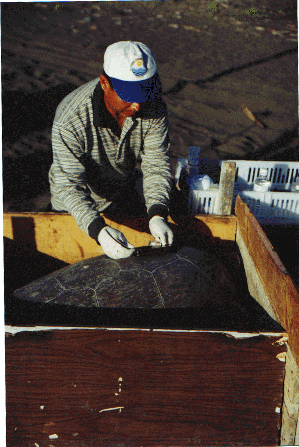
Satellite Tracking of Green Turtles in the Gulf of Mexico (website)
This project is a cooperative effort between the Oceanic Resource Foundation and the Mexican Environmental Organization INP-CRIP-VER (National Fishery Institute Veracruz). Satellite transmitters were attached to two green sea turtles, Chelonia mydas, on a nesting beach in Veracruz, Mexico. The migratory routes of these endangered green turtles overlap with several fisheries in the Gulf of Mexico. Entanglement in fishing nets is a major cause of mortality within this threatened population of sea turtles. Information from this study on migratory routes, feeding ground locations and habitat utilization may rove useful to conservation management decisions.
Telonics ST-18 satellite transmission tags were attached to the turtles in August and September 2000. The turtles' movements have been monitored by collecting longitude and latitude readings using the Service ARGOS Satellite System. Both turtles have migrated in the Gulf of Mexico from their nesting beach near Veracruz, Mexico to a feeding area called Tortugas Bank off the Florida Keys.
Download:
Pictures:
United States Geological Survey Gap Analysis Program (USGS GAP) (website)
The Gap Analysis Program (GAP) provides information on the distribution and status of native plant communities and animal species in order to provide land managers, planners, scientists, and policy makers with the information they need to make better informed decisions.
In 2001 and 2002 GAP will map land cover and predicted distributions of vertebrate species, and overlay the maps of these biotic elements with maps of land ownership and types of biodiversity management, so that the degree to which vegetation types and vertebrate species are represented in protected lands can be assessed. GAP provides first-ever snapshots of biotic distributions and status over large regions at detailed spatial resolution. In 2001 and 2002 the GAP is also coordinating with Mexico and Canada to develop similar programs. Throughout the IBOY the GAP will issue reports and datasets on the conservation status of biodiversity across the USA and will assist in the development of similar Canadian and Mexican reports, for continental-wide assessments.
Last updated December 4, 2002
IBOY took place during 2001 and 2002 and is now completed. Information on the projects, activities and products that took place during IBOY are available on these pages. Many of the projects are still continuing their research and education activities and links to their homepages can be found on the project pages.
For more information on on-going activities of IBOY's parent organization, DIVERSITAS, see http://www.icsu.org/DIVERSITAS
What's
New
| About IBOY | Projects
| Publications | What
you can do | Meetings | Resources
| Kids
Contact IBOY | Copyright
| Disclaimer