|
Report of Workshop Held at the International Livestock Research Institute Nairobi, Kenya July 6-8, 1999
Initiation - Michael Coughenour1 and Robin Reid2 1Natural Resource Ecology Laboratory Colorado State University Fort Collins, Colorado 80523 2International Livestock Research Centre P.O. Box 30709 Nairobi, Kenya
Organization - Cathy Wilson, Mike Rainy Facilitator - Ole Kamuaro Reporting - Judy Rainy, Mike Rainy, Eoin Harris
Colorado State University Subproject Global Livestock Collaborative Research Support Program
Funding - Regional Economic Development Services Office (REDSO) for East and Southern Africa, U.S. Agency for International Development (USAID)
Colorado State University (CSU) and the International Livestock Research Institute of Nairobi (ILRI). are collaborating in the USAID Global Livestock Collaborative Research Support Program (GL-CRSP) on a subproject called "INTEGRATED MODELING AND ASSESSMENT FOR BALANCING FOOD SECURITY, CONSERVATION, AND ECOSYSTEM INTEGRITY IN EAST AFRICA". The objectives are to improve ecosystem and natural resource management of wildlife-livestock ecosystems in East Africa and, to help ensure that development of livestock-based agriculture in this region do not negatively affect wildlife, natural resources, and the life-supporting ecosystems of the region. This will be achieved through integrated ecosystem assessments that provide accessible and useful information to resource managers, decision-makers, policy-makers, land tenants, and other stakeholders in the outcomes of human-induced changes to these ecosystems. An Integrated Modeling and Assessment System (IMAS) is being developed, consisting of spatial data bases, geographic information systems (GIS) analyses, spatial-dynamic computer models of ecosystems inclusive of humans, wildlife, and livestock, and field assessments that provide the information required to conduct integrated assessments. The IMAS portrays the likely ecological and economic outcomes of current trends and alternative scenarios of policy and management among local through international stakeholders. The IMAS can be used as a framework for more informed discussions and negotiations among various stakeholders in a particular ecosystem. The IMAS is being implemented at two sites during the initial 3 years of the GL-CRSP study - Ngorongoro Conservation Area (NCA) in Tanzania and Kajiado District, Kenya. In the NCA, the IMAS is being adapted to simulate historic and current patterns of land use by the Maasai and by wildlife, to represent the degree of competition between livestock and wildlife for forage and habitat, and interactions involving animal diseases. Changes in livestock and wildlife abundances, human land use, and climate utilization are being simulated, along with their combined impacts on the vegetation and soil. The REDSO branch of USAID was interested in exploring the possibility of applying the IMAS to improve coordinated management of transboundary ecosystems in East Africa. CSU and ILRI organized an assessment process for this purpose. A workshop was organized to conduct that assessment. At the workshop, we explained the IMAS, and showed how it has been used to address ecosystem management and policy issues in the Ngorongoro Conservation Area. This demonstrated the capabilities of the IMAS, and provided a framework for further discussion. We hoped to establish working relationships with and among Kenyan, Tanzanian, and Ugandan organizations to apply the IMAS to East African regional ecosystems. African partners would be identified and we would formalize collaborative working relationships in the development of the IMAS for a particular ecosystem. We explored the possibilities of using the IMAS for strategic coordinated management of transboundary ecosystems in general, but we focused on the Greater Serengeti-M ara Ecosystem. Workshop participants described their perceptions of the issues that we would have to consider to apply the IMAS to the Greater Serengeti-Mara. We hoped to identify some of the difficulties currently experienced in the management of this ecosystem at local through international levels, identify issues which could arise in the future, and the possible consequences for the ecosystem as a whole.
The Maasai-Mara Reserve, Serengeti National Park, Ngorongoro Conservation Area, and other administrative areas comprise a single Greater Greater Serengeti-Mara Ecosystem, defined by the movements of large herds of migratory wildebeest, gazelle, and zebra. While the Maasai-Mara is in Kenya, the other management units are in Tanzania. These politically distinct units are ecologically and socio-economically connected by the movements of humans, wildlife, plants, information, water, airborne materials, goods, and money. The migratory wildlife do not recognize international boundaries, and their fate is influenced by the independent policies of two different countries. The significance of transboundary interactions is exemplified by potential secondary effects of land-use changes surrounding the Maasai-Mara. Increasingly, arable lands are being converted to cultivation, while the pastoral herds put increasing demands on the remaining grazing lands, which are also important grazing ranges for the migratory wildlife herds in their annual cycle of movement between Tanzania and Kenya. Conversely, increased land preemption and poaching on the western boundary of the Serengeti may increase migratory wildlife grazing pressures on the Mara. Resulting decreases in wildlife could have serious economic consequences for both countries, and changes in wildlife distributions could disrupt the ecosystem as a whole. Pastoralists and their livestock do not necessarily recognize international borders either. Movements of livestock accross the border area may be vital for pastoral welfare, including regular movements among seasonal grazing ranges, and contingency movements to different grazing ranges during local or regional droughts. Animals may also be moved across the boundary to sell in markets in southern Kenya, or to replenish Tanzanian herds with animals purchased in Kenyan markets. At present there is very little information on such movements. Wildlife and livestock movements across the boundary present a significant challenge in managing animal disease. Infectious and parasitic disease agents of wild animals within the Serengeti-Mara ecosystem not only affect the mortality, natality, and well-being of wildlife, but also can be transmitted between domestic animals and humans in the adjacent environment. Unregulated transboundary movements of livestock and wildlife means that lack of disease control in one country can have consequences for the other. Diseases of wildlife and domestic animals in the Serengeti-Mara ecosystem not only affect animal populations, but their occurrence and control also have economic, social, and political implications. Clearly, the Greater Serengeti Ecosystem, inclusive of the Serengeti National Park and Maasai-Mara Reserve, must be managed as a whole, and there is a need for coordinated management by authorities on the Kenyan and Tanzanian sides of the border. There is a danger of the independent authorities working at cross-purposes, with detrimental effects to both parties. Decisions made on one side of the border affect ecosystem components on the other side and the negative consequences may feed-back to where the original decisions were made. Thus, it is to the benefit of decision makers on both sides to recognize these transboundary interactions and develop a coordinated plan for natural resource management and food security development.
Rapporteurs – Mike Rainy, Judy Rainy, Eoin Harris (Note - The following is the rapporteur’s record of the proceedings of the workshop, not direct quotations or writings of the authors, except for copies of original figures and slides which were obtained from the speakers. Model results presented herein are also preliminary. Statements and model results should therefore be interpreted with caution.. We apologize to the speakers and participants if there have been any inadvertent misquotes.)
Ole Kamauro – Introduction Welcome everybody to this workshop. Can the 36 attendants introduce themselves?
Having been raised in Texas, I can see many parallels with the situation in the Mara - Serengeti with respect to livestock development and wildlife interactions. The issue is an important one. ILRI is 1 of 16 international Agriculture Research Institutes supported by 58 donors of which the governments of Kenya and Uganda get US$350m (split 16 ways). Others supported by this are ICRAF and CIMYAT. ILRI has always focussed on livestock while the other institutions have now been bringing livestock into research. There has been an overwhelming increase in demand for livestock products and therefore there are needs to bring subsistence economy into the market economy. Along with this need, there will come larger impacts on the natural resource base. The research carried out through CRSP aims to address these needs. However, our visions must look ahead 10 - 20 years and not just to the next election. ILRI deals with large portfolio its research associates work within different spheres for example from the molecular biology of disease, right through to agricultural development. The recent concerns about the role of biotechnology in agriculture from the western world have come from those who are living in the lap of luxury. There is a certain amount of arrogance in this as the criticism is from the consumer societies and not from those whom the developments are most needed. There is great concern that the problems cannot be resolved despite the research, as political decisions are often made with little basis of information. There is great need to consider the requirements of people in agriculture as these needs are required for food production. However, current agriculture and development could be at the expense of future generations and therefore development must be implemented with caution. Partnership between agriculture research is important especially through efforts such as the CSU/ILRI CRSP project, and through development of information tools such as the IMAS. It is essential for agricultural development to take place without jeapordising the future. This will guarantee more food and products for the market over the long-term. Thanks to USAID for the continuing to support the efforts of the CSU/ILRI CRSP.
Thanks to ILRI, Cathy Wilson, the attendants, and Ole Kamauro for their roles in this workshop. The project’s overall aim is to balance food needs and security through livestock and at the same time remaining amenable to wildlife. Development cannot come at the expense of wildlife, as wildlife is important economically in East Africa. Conversely, wildlife protection efforts do not necesessarily need to impair the development of livestock-based agriculture. Tourism accounts for US$2 to 12 billion per year in developing countries for example; Kenya earns US$400 million from tourism, 80% of this is by wildlife. In Tanzania 326,000 visitors came last year earning the country US$ 375 million, tourism in Tanzania is projected to be the number one foreign exchange earner by the year 2000. Most importantly, tourism stabilises economies in developing countries. The development of Pastoral/wildlife areas in East Africa are characterised by: increasing human population, increasing land use intensity, regional decreases in both wildlife and livestock and a decreasing human to livestock ratio. Livestock and wildlife are historically compatible but increasing human pressure and has led to the systematic exclusion of wildlife. Wildlife/ livestock competition is poorly understood and critical ranges for both wildlife and livestock have been lost through poor planning. These changes have generally destabilised grazing ecosystems and have led to human food shortages. Both conservation policies and development policies ultimately affect land use and land management. Ecologists try to understand land-use dynamics and what happens following a particular land-use change policy implemented by economists and planners. This also applies to the different forms of wildlife utilistaion that in turn affects wildlife diversity and human land use. Herd management is important in this context as it ultimately affects household wealth and herd wealth. These problems are not exclusive only to East Africa but can be seen in examples in the United States. For example bison straying from Yellowstone National Park are herded back into the park by rangers, as they are perceived by the ranchers adjacent to the national park to be a source of brucellosis. There is in this case a conflict between agriculturists and human land use. Savanna was used to help solve the problem in Yellowstone National Park, which has multiple land use agencies. The issues faced by Yellowstone National Park are, brucellosis in bison, snowmobile trails in winter and bison population dynamics with respect to migration. The solutions to these problems were; spatial modeling and GIS to determine carrying capacities and field studies of plants etc, which were covered by the CRSP team. These problems were not confined to the Yellowstone National Park itself, but were also evident in the Greater Yellowstone Ecosystem. This demonstrated that a National Park interacts with its environs and it does not have fenced borders but rather boundaries that follow political lines. What happens within the borders affects what goes on outside. Another multiple agency issue, which Savanna was involved with, was in the Rocky Mountain National Park where an increase in elk numbers is having negative impacts on the vegetation. There is a parallel increase in human land use intensity on the periphery of the park as elk from the park are commonly found in the nearby town. A decrease in the efficacy of hunting has changed the population dynamics of the elk making, further compounding the problems. Again the solutions to these issues are spatial ecosystem analyses and GIS and field studies of vegetation growth and herbivory. The goals of the CSU – CRSP are to balance food security and ecosystem integrity through collaborative research in the US and East Africa as well as other projects in East Asia and Southern Africa. The Integrated Modeling and Assessment (IMAS) approach applies to the modeling of ecosystem processes; GIS, disease, socio-economics and other user interfaces. Stakeholders and planners need to be provided with information, empowerment with information. The IMAS facilitates the processing of information to enable all participants to act effectively through the availability of such information. The goals of the project are fourfold:
So we are looking for the key players and marry this with the best scientific information that we have.
Welcome everybody to the workshop. ILRI is concerned about all of these issues to produce solutions for poverty in the pastoral sector. People that are in this room today are not casual observers to the proceedings but have been invited as they are key players. ILRI – as the name suggests that this is an international organisation that is concerned with livestock and the environment that is involved with research to provide information and tools to stakeholders. ILRI’s mission statement is to improve the productivity of small holder livestock systems and to protect natural resources. The aim of the workshop is to bring a diverse range of information together and to look beyond our own personal interests. Two groups of people work within the project: Systems Analysis and Impact Assessment. The following is a representation of how the analysis takes place.

It is essential to know how systems function so that we can look to the future and predict what might happen within these systems. Impacts In systems analysis we need to know what kind of impacts we are having and where they are, what kind of impacts are we having and where e.g. livestock and agricultural production impacts and welfare impacts. GIS is one tool that we can use to look at this. What is the value of impacts? I.e. surplus, models and household models. ILRI uses field studies, modeling and GIS to solve these problems and bring knowledge to the stakeholders. This workshop is a chance for the East African stakeholders to direct the Colorado team with their needs and wants.
The interaction between science and socio-cultural lifestyles has been very egoistic. Over the next couple of days we aim to go beyond these barriers. Here we will see how high level sophisticated science will be brought to traditional peoples. The aim is to show to these people hope of maintaining a functioning ecosystem while maintaining and increasing economic benefits. The question is, what is the conservation policy that will allow for this? Two conflicting factor have arisen: an increase in human populations and a decline in wildlife numbers (DRSRS data shows that there has been an 18% decrease in the Mara wildlife populations in the last 20 years), yet with these factors the Mara must maintain its high tourist numbers. The community should realise the importance of the Savanna model’s use in sustaining wildlife numbers in the face of economic development activities. Through the model, the science and GIS part of the process can be demystified. The important point here is that the scientists are making themselves useful to our communities, so we need to learn from them and to join them to maintain ecosystem integrity. Since there are parties from both sides of the border here, we need to share our experiences and we need to make our feelings known about which is the best way forward. The Mara is one place, in my opinion, that needs our attention - due to increasing population pressure and unchangeable land use patterns.
The general perspective of REDSO’s Natural Resource Management (NRM) program comes from the need for economic development and increased food security. The NRM faces the challenges of helping to manage natural resources in the face of increasing human population. This requires knowledge of who is involved and how and provides information to perform analyses which ultimately results in the formulation of policies. NRM looks far into the future and not to immediate political responses. The goal is to improve ecosystem and natural resources management by providing the basis of informed dialogue through the increased accessibility to useful information. The promotion of effective collaboration between stakeholders and the strengthening of African capacity to ultimately improve how decisions are made. USAID’s role in this process
How does Mara/Serengeti fit in to these aims? It acts as a case to identify the key issues, the key stakeholders, the uses for the model, and to develop answers to these issues. Challenges for the participants in the workshop
The workshop will likely result in potential applications for further development
The aim of this section of the workshop is to offer a simple introduction on modeling, how it works, what its implications are - to highlight the simple ideas associated with modeling. The basic idea of a model is to make complex issues as simple as possible to comprehend. Here a model will be defined, the different types of model described, the advantage and disadvantages of modeling discussed and the fundamental ideas behind model building presented. Definitions of modeling. A model is a substitute for an object or system and is a set of rules and relationships that describe something. All thinking depends on modeling. "If you try to tell somebody what you are thinking then that is modeling." Definition of a system. A system is defined as a grouping of parts that operate together for a common purpose. Each part has a specific function that allows the group to work as a greater whole. Some other definitions of a system:
The "whole" is always greater than the sum of the parts. The human brain has problems thinking about complex systems; so there is a need to break down complex systems into simpler parts. Modeling is a tool that helps us do that. Why focus on Model Building? Model building serves as a means of organising information to clarify and record what we know, it also acts as a means of communicating information and identifying information gaps. Through the model building process the modeler repeats and clarifies assumptions. Finally, the model can be used to predict outcomes. System models are a means of communicating what we are doing. Although model building makes communication powerful it may not make it easy. It often has one major drawback in that obtaining information for the model, we often find out about things that we did not know or consider. When building models, we can make assumptions but we must be clear about those assumptions. Models display the results of our formal thinking, if we can predict from this thinking then we have been successful, but in most cases we cannot say that we have a predictive model but we have clarified our assumptions. Prediction is not the primary goal of model building, the explanation of our thinking is. Criteria for judging a model’s advantages and disadvantages
Judging the model Simulation models are easy to manipulate, comparatively speaking. Do not judge the model on preciseness of the results but rather on how the model helps us understand and explaining the whole system. Types of model.
Basis of structured model usefulness – how to judge a model Model validity is a relative matter i.e. valid to what? The reality is that we do not have perfect information about ecosystems, we do the best with what we have, as there are few or no process for which we have no information. Is data acquisition better than data collection? Sometimes yes and sometimes no. Models should not be compared against imaginary perfection but should be judged for clarity of structure against other models. Models should be judged by the ease of communicating the interactions of the parts.
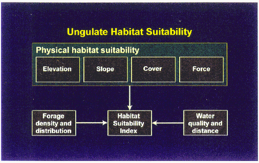
The Savanna model was first developed for a nomadic pastoral ecosystem in southern Turkana District, Kenya. The aim was to model spatially extensive ecosystems (i.e. where people are/ what they are doing when and why) using an approach that focuses on ecosystem processes. Interactions between ungulate herbivores and plants needed to be represented, to assess plant responses to animal herbivory.
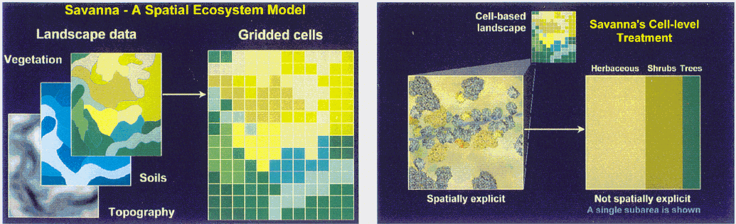
The Savanna model has a number of submodels, as shown here. These consist of plant and soil submodels, herbivore submodels, and a predator submodel. Topography, soils and vegetation maps provide polygon data that is converted to grid-cell data, or "raster" format. The model simulated a grid-cell -based landscape that is spatially explicit. Within grid-cells there is a fine level of detail in that the model differentiates areas which are covered by trees and those areas which are not covered by trees. At the subgrid-cell level, the data is not spatially explicit. It cannot keep track of every single tree within a grid-cell, as computers currently do not have the ability to deal with this detail of information. A summary of how Savanna deals with this type of information is shown here.
Savanna has a variety of time frames: weekly time-steps are used to update the state of the system. Outputs of the model are monthly. Simulations are typically run for 5 to 100 year periods.
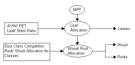
The model also takes into account the water balance present within the vegetation. Here precipitation is partitioned into that which in intercepted by canopy, that which passes through the leaf canopy and that which percolates through the soil to the deeper tree roots. Tree population dynamics are addressed by the tree sub-model, which represents the aging of trees by placing trees into size cohorts, and keeping track of the number of individuals in each size class. It also takes into account reversals within these dynamics, which relate to fire, herbivory and human utilization.
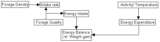
Forage intake rates are calculated by considering both the amount of forage present and its quality. Forage intake then affects the animal’s energy balance. The ungulate energy balance submodel compares animal energy intake to expenditure, which then determines the condition of the animals. The linkages between animal condition and reproduction and mortality rates are important for predicting how ecological conditions affect animal population dynamics.
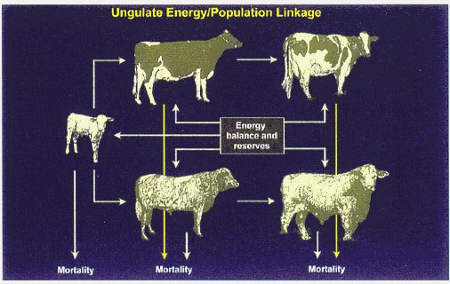
The ungulate energy model is linked to a basic population dynamics model, which takes into account mortality and recruitment in relation to the amount of energy present to the animals.
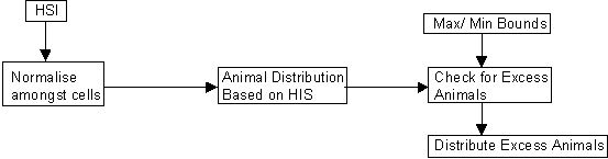
Ungulate Distribution Model This links the distribution of animals to the amount and quality of forage and the distance to water. This is referred to as the habitat suitability index. The path by which Savanna distributes animals within the landscape is shown in the diagram below.
The Savanna model is only one component of the IMAS. The IMAS also includes GIS analyses, an animal disease model, and human ecology models. Savanna provides an link between GIS data and the human ecology models. The modeling team is currently working to develop the human interface of the model with the incorporation of the disease, economic and human ecology sub-models. As well as developing the user interface, they are also monitoring the outcomes of the model. Ole Kamauro: Why did you call the model Savanna? M. Coughenour: The first use of the model was applied to the complex mixtures of trees, shrubs and grass, and a diverse mixture of livestock in Turkana. As a result, the model is applicable in many different environments. Since savanna ecosystems contain a wide variety of plants and animals it seemed fitting to name model "Savanna.". Ole Kamauro: Why did it take so long to develop? M. Coughenour: The Turkana project was part of a pure science investigation, to develop a comprehensive understanding of the ecosystem and to answer questions about how the system persists in the face of an unpredictable and stressful environment, for example. The Turkana project was not funded to develop user-friendly software tools in a short period of time. Of course, we had hopes that the understanding we developed would ultimately be useful for improving ecosystem management and decision making, but the application was not in our purview. I think we are now seeing some payoff from that work, back in Africa, where it originated. J. Grootenhuis: Could you define "people tools"? M. Coughenour: People tools are the ‘user environment’. This is to improve people’s understanding and to facilitate the interaction of people with computers such that they can use the model effectively. J. Grootenhuis: What about computer literacy as applied to the model use? M. Coughenour: Not everybody needs to know about the mechanical workings, an additional layer of users (computer operators) operates the model for the end users. B. Woodmansee: This will be highlighted later in the workshop. M. Parkipuny: Is there a connection between the Savanna model in Turkana and its current form? T. McCabe: A lot of the data used come form Turkana such as the patterns of weight loss during dry seasons and general pastoral movement patterns are still used in the model. W. Mutero: Who is the model targeting? M. Coughenour: The model targets stakeholders i.e. planners, ecosystem managers, policy makers, people on the ground interacting with the ground on a daily basis. R. Reid: It also has a wide range of potential uses such as data collection and IMAS. For example the Rainy's with Naftali Kiyo in Amboseli Park. Ole Kamauro: Community groups would have to identify people to train thereby promoting the filter down of information. Ultimately this would correct the misunderstanding between local people and scientists. Local communities are both the users and mis-users of habitats and therefore require a tool like this to help them manage their resources. Community groups are very critical of this. Q: But don’t the Maasai already have a traditional land use management practice? Ole Kamauro: Yes, the traditional practices worked 30 years ago but the intensifying land use in the Mara and pressure to get more income and yet maintain the habitat integrity are the challenges the traditional model cannot keep pace with.
Ngorongoro is a very special place on this planet. It is a spectacular landscape with a varied combination of highland areas, forests, and grassy plains. The Ngorongoro Crater is the largest collapsed caldera in the world. Empakai Crater is extremely picturesque, and there is often a ring of flamingoes poised around the lake at the bottom. Oldonyo Lengai is the only active volcano in Africa. There is also the abundance of wildlife within the Ngorogoro Crater and the famous wildebeest migration from Serengeti occurs in January to March. The NCA has also been the scene of very important archaeological discoveries. The work on the human species originated from here at Laitoli. It is also the home of 42 to 46 Maasai Pastoralist families and is the longest history of trying to combine pastoral people’s development whilst maintaining the wildlife resource. However, there are problems with people and wildlife in the area. The traditional Maasai lifestyle is compatible with conservation. But, people are not frozen in time, and the Maasai of the NCA are not socially static. For example, Maasai have been developing small-scale business in Endulen. This has never been seen before. The History of the NCA The NCA is one of the longest multi-use experiment areas in Africa. Both small-plot cultivation and pastoralism were allowed when the area was formed. However, in 1975 cultivation was banned. The ban on cultivation was temporarily lifted in 1992, and in 1997 was lifted completely. Findings from my 1989 study
Wildebeest migration The migration is a wonderful thing but it poses managerial problems for pastoralists, in the form of MCF – malignant catarrh fever. This disease is spread from the nasal and ocular secretions of wildebeest calves and is 100% fatal to cattle. It is present for up to 2 months following the wildebeest calving period. The wildebeest population rose from 240,000 to 1.4 million in the period 1960 to 1974. (In the last few years it has declined to at least 900,000. The increase has meant that the Maasai could not go to the plains that they had normally used for their wet season grazing, as they were now unable to avoid the wildebeest calves and MCF. The only way to avoid this was to give up the wet season grazing during the months that the calves are present. When the Maasai bring their cows back to the plains there is usually very little forage left after the wildebeest. Cultivation 1995 – resurvey addressing the same issues as the previous study, which is becoming increasingly important to the Maasai.
In general, people felt better about their lives and felt that they had more control of their lives in the 1998 study since the cultivation ban was lifted. However, conservation and human diversification is not an easy option to follow, in general conservation areas in East Africa are based in areas with a pastoral existence. Tourism generates revenue and supports natural economies and people therefore benefit directly from conservation, however there is conflict as lodges have used traditional dry season springs as their water source and pastoralists have been excluded.
The overarching goal is to apply the Savanna model to NCA to model the interactions between climate, plants, livestock, wildlife, and people. This model can then be used to conduct assessments of livestock-wildlife interactions under different climatic and management scenarios.
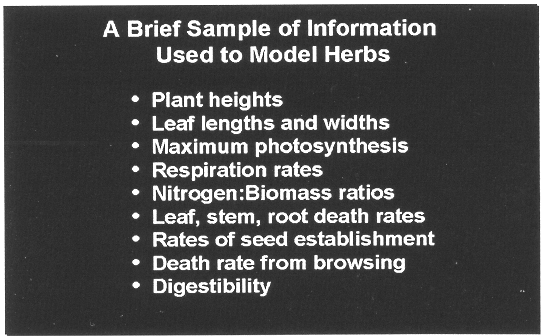
Model inputs are shown below. Herbaceous Plant Functional Groups
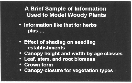
Woody Plant Functional Groups
Other data that feeds into the Savanna model includes weather data from 55 weather stations across the NCA (provided by Ken Campbell, of the former Serengeti Ecological Monitoring Programme). A large amount of spatial data including elevation, topography, aspect and slope, which is essential input into the model. These additional sets of data are shown below.
Both soil maps and current vegetation maps for the NCA are used in the model. The NCA control model makes use of the soils maps that were produced by the FAO who replotted the original map using vegetation types.
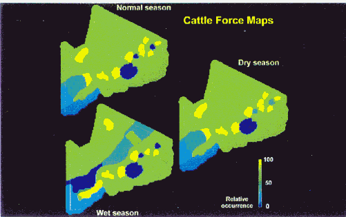
Cattle "force maps" as shown in the image above, are used to implement pastoral grazing patterns, and the legalities as to where /when people can graze cattle. For example there is no grazing in the crater areas. Other areas considered by the force maps represent places where there is conflict with adjacent tribes this therefore lowers their value with regard to grazing. Importantly the force maps allow for the band in the south-west of the NCA where the wildebeest calve and therefore where Malignant Catarrh Fever excludes cattle during the wet season. Goat and sheep force maps prevent them from contracting MCF and therefore can go into the band that is excluded to cattle. Other information used in Savanna
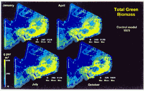
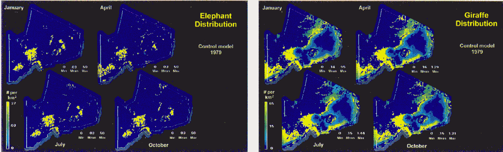
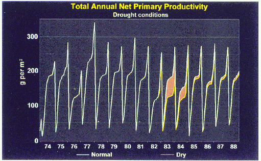
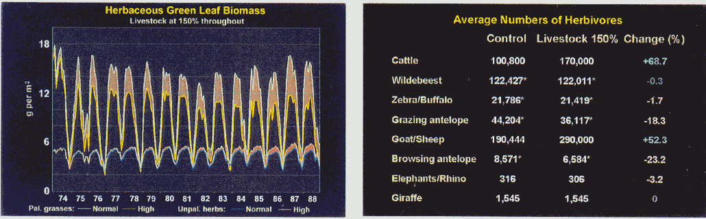
The control model runs are those runs of the parameterized model which are conducted for a set of standard conditions. This provides a basis for comparison of the results of experimental runs to be described later. The model was run between 1974 and 1988, as this was a reasonable period during which climate data was available. 1979 represented an average distribution of rain throughout the year
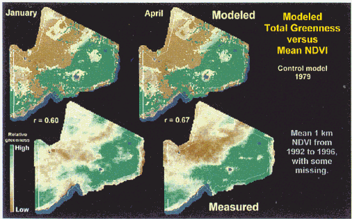
It is possible to compare the amount of modeled greenness with the actual amount of greenness on the ground by comparing the Savanna output to the NDVI. The bottom row of figures shows the amount of greenness as applied to the NDVI during the wet season, whilst the top row of figures shows the greenness as modeled by Savanna during the same period. Savanna explains 40% to 50% of the variation in greenness. A similar result was obtained for the wet periods. The comparison of estimated greenness and measured greenness using a standardised scale is shown here. The study compared only 16 sites as 6 of the sites for grassland fell into another vegetation category.
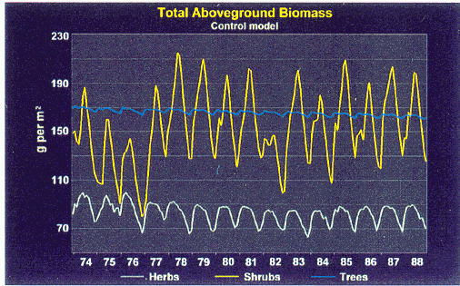
One problem that was realised during the development of the model was that here it was assumed that peak biomass would occur in the wet season. However, the wildebeest are in the area and graze the grass short, peak biomass is therefore after the peak in rainfall as the grass has time to recover after the wildebeest have migrated.
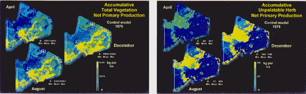
Spatial comparisons of the Net Primary Production (NPP) are shown above. The image on the left shows the accumulative total vegetation NPP, whist that on the right shows the NPP of the unpalatable herbs. The areas utilised by migrating wildebeest can be seen clearly as there is a greater NPP following heavy grazing. Multiple layers are modeled so these maps reflect the amount of woody cover in the area and also the age structure through time.
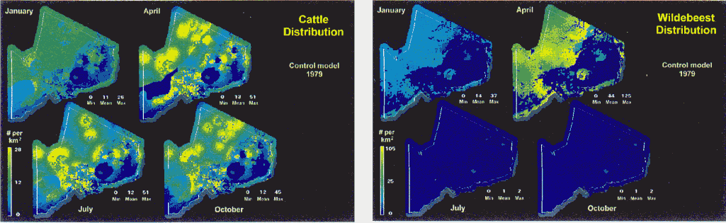
The model keeps track of the proportions of the animal functional groups that occur in the NCA through time. Whilst there are not other animals in the NCA, browsing antelope make up 60% of the population throughout the year. In January only 40% of wildebeest are present in the system; the rest migrate in.
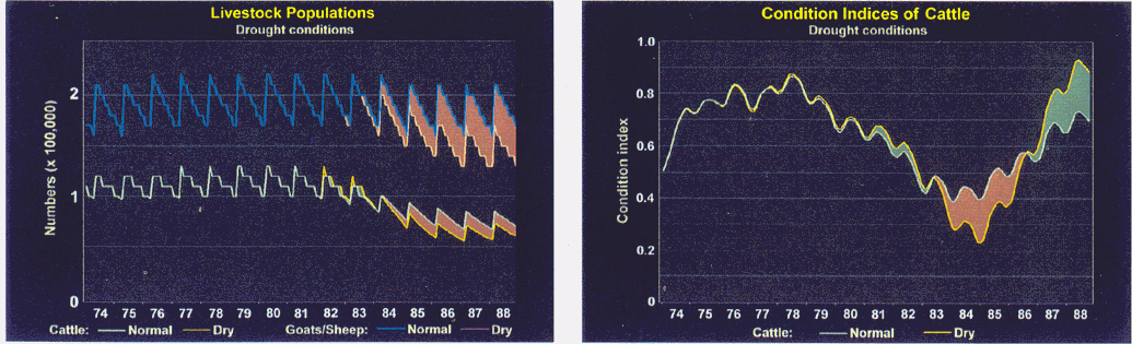
The total populations of gazers and browser are shown above. It is noticeable that during the 1982, 1983 and 1984 dry-periods that there was a significant decline in the cattle population of the NCA. There are approximately 115,000 cattle on the system and 19,000 to 25,000 shoats in the system at the end of this control run.
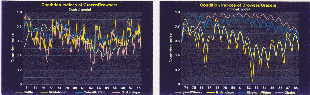
The condition indices are shown above for the two groups of animals. Grazing animals are shown on the left and browsers on the right. A condition index is formed from the mean body weight for the population and is compared to the minimum and maximum body weights for a population (Min = 0, Max = 1). The condition index is also closely linked to the other recruitment factors. The effect of dry years is seen significantly in the condition of various animals, particularly both the grazing and browsing antelopes. Q: Does the model take into account migration out of the system? R. Boone: You need to define the system limits in order to construct a model. Once the animals leave the system, they are not simulated. However, the model does account for seasonal in and out migration of the herds from the Serengeti by removing or adding animals to the NCA system at specified times of the year.
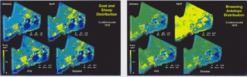
The distribution of elephant is very closely linked to the water sources. Conversely, the giraffe are not restricted by available water and tend to avoid the forest highlands but rather follow the shrublands in their distribution. At present, the control model does not include information for households, agriculture and livestock deaths related to disease and livestock ‘leaving’ the system due to sales or butchery. These factors are soon to be included into the model to improve its accuracy. Is Savanna modeling the NCA correctly? If it is and these results have shown that it does, then we can address it with questions. Some of the potential management questions that the Savanna model can be used to address are:
Q: What is the size of the cells in the model? R. Boone: We used 5km2 cells to parameterise the model and 1km2 blocks for the final NCA runs. The total area of the system includes 8500km2 plus 5 km buffer = 10,000km2. Q: Is the model a vector model? R. Boone: No, vector modeling is very difficult in this type of modeling as each cell has all of the information that applies to it e.g. soil, animal density, plant density. Q: How does the model react to drastic events? R. Boone: The aim of the model is to see how the ecosystem might react to such drastic events. The model also has feedback mechanisms that prevent the propagation of errors, which keeps the model in check. M. Rainy: what will you be able to say about mammalian biodiversity? R. Boone: The model is not really representing biodiversity as the animals are classed into several functional groups.
Based upon 32 years of work in the greater Amboseli ecosystem, it has become clear that there is a need to provide a richer and more useful body of information through Integrated Modeling and Assessment. In that period of time, so much has changed and he would like to see the Amboseli ecosystem used as an IMAS case study to assess the challenges and changes that we are facing. The Savanna model is unique as it keeps track of the interactions between grazing and browsing animals in time and over space. This is important because, for instance, grazing animals are water-bound, whereas browsing animals are more uniform in their distribution. Amboseli shows pulses of these two animal systems in time, so the interaction is differentially distributed in time and space. The definition of ecosystem boundaries is paramount to the assessment. For example, with the right system boundaries, the model could be used to look at why the zebra and wildebeest suddenly move out to the Sirya escarpment, when they do not normally utilise that area. Many of the patterns seen in Amboseli are similar to those of the NCA. Animal movements follow a similar pattern of movement to short grass areas during the wet season, giving rise to conflicts between wild and domestic species outside of the national park. However, exclusion by disease is not such a major issue here. The easiest way to understand this is to follow cattle movements yourself, but this is of course affected by agricultural, social and disease factors. If we parameterise the model using physiological principles, the model should show realistice the changes between the wet season and the dry season in plant abundance and animal distributions. The model should predict where animals will move during the year. Movements form wet areas to drier areas, to shorter grass, and movements to the swamps in the dry season are all predictable. At present the data can only show these changes temporally, but with the Savanna model, these changes can be mapped spatially. A long-term set of data exists for Amboseli, which should allow for these kinds of predictions. This would enable us to see how the whole Amboseli ecosystem is changing. As a result of changing land-use the entire economy of Amboseli is changing. There is a transition from a purely pastoralist system to an agriculture-based system. People are therefore making trade-offs with tourism and trading. The driving force is land use change that is linked to the larger global economy to diversify. Originally the Ivory trade was a factor here but this has changed. If we can show that we understand the ecosystem in this way, then we can set about establishing an aim for the ecosystem, encompassing views from outside conservation from a neo-agriculturist, pastoralist, and tourism perspective. Each of these groups has its own set of values which determine what they believe the ecosystem should be doing. Ultimately we are looking at a different ecosystem each time from each of these viewpoints. Tools are needed to show the outcomes of alternative land use change scenarios, relative to the objectives of each stakeholder group. What is needed in an Ecosystem Viability Analyses. Three factors come into play here:
Rainfall and the interactions between livestock and elephants drive the Amboseli system. Elephants will flood into the system by the need for security whilst outside there is a decrease in livestock habitat. In Kenya we are seeing the following habitat changes: National Parks are turning to grasslands; Outside the National Parks there is transition to bushland Amboseli and other national parks used to be a mosaic of habitats, now 50% of the former plant species in 8 distinct communities present in Amboseli have been lost, therefore the problem of biodiversity has not been solved for Amboseli. The tension between the eating habits of Elephants and Cattle create shifts in biodiversity. In 1995 a 2-day meeting of stakeholders in the Amboseli system was held, after this everyone was unanimous that there was a need for space. This was the basis for the construction of the fences and the rehabilitation of boreholes outside of the park. Amboseli has the most amount of information of all the national parks, yet less than 1% of it has been used for policy making. This is a challenge for the CRSP project, as it needs to adopt an approach starting from common ground, taking into account the conflicts of interest. All the models need to be brought to the meeting table, to identify the problem areas with information becoming the currency of negotiation. Ideally, the model would be generalized further by identifying the least number of variables which gives the maximal amount of information. The model could be more easily applied to a larger number of sites using rapid assessment and monitoring. We need to identify a Minimum Viable Conservation Network that consists of the highest priority areas for protection. This network would addresses when, who and where we have to address the problems with emphasis on the trans-border issues. The Savanna model should be used as an aid for negotiating this network, by showing where the most important threats are and why it is important to protect certain key areas. We can also use the model determine who to involve in the negotiations for network establishment, by showing relative impacts on different stakeholders.
The aim of the socio-economic model is to develop a dietary energy flow and cash flow module for the IMAS, i.e. the human ecology aspects of the model. At present the work has focused on the economics of group ranching in Kajiado District, with the focus on wildlife dispersal areas around Amboseli National Park. Three different household types are represented; rich, medium and poor. For each household dietary energy flow, cash flow (household expenses division), household sales, cropping decisions and cattle/ shoat herding dynamics are calculated. The approach takes a top – down approach, using with a set of a few decision-making rules, rather than a more mechanistic bottom-up approach. The rules used in the model are tested and adapted as necessary to be consistent with actual human behavior. Cashflow Inputs: Livestock sales, crop sales, wages, milk sales, gifts/ crafts etc. Outputs: Household goods, food, livestock purchases, other (crop inputs). Dietary energy flow Household energy requirements are described by:
These requirements are met by:
Energy Algorithm 1 Energy Algorithm 2 Welfare ratios A key concept is use of human welfare ratios to affect household decision making. These are defined based upon the following quantities: TLU – Tropical Livestock Units per adult equivalent CL – Cash Left per adult equivalent Target levels of each ratio are specified, for instance a target TLU and an target cash left, for which the household is trying to manage to. The model keeps track of actual TLU (ATLU) and actual target cash left (ATCL). The ratios of actual to target livestock and cash levels express the departures from target conditions. These ratios can therefore be used to prescribe the appropriate management intervention to move the household closer to the target. Based upon the values of these ratios, livestock are sold or purchased. Different household types (wealth levels) use different criteria for buying an selling. The next steps required to further develop the model are to:
Scenario Analyses Finally, a scenario analysis will be conducted with the model. The model will be used to assess what happens if:
Results can be used to assess the impacts to human welfare, of possible future changes in livestock abundance and productivity that might arise from different land use policies, economic policies and conditions, and levels of interaction with wildlife. M. Coughenour: Indeed, coupling of the two models will allow us to see the effects on human welfare of different wildlife or development policies. M. Rainy: Does this allow for economies becoming more modern and becoming part of the larger economic universe? P. Thornton: Yes, we are currently looking at more market-orientated economies in Kajiado. Traditional economies are actually much harder to incorporate into traditional economic theories. More modern factors such as tourism are more easily incorporated into the model. M. Parkipuny: Is the traditional use of plants incorporated into the model? M. Coughenour: Not as yet as this would require analysis at a species level.
We are interested in looking for continent-wide patterns within rapidly changing landscapes and to ask the question why worry? In this presentation, the aim is to address the following questions:
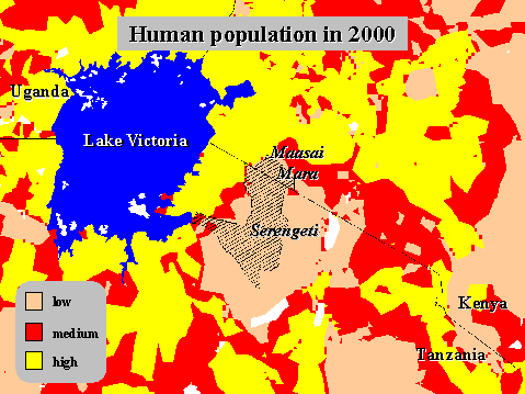
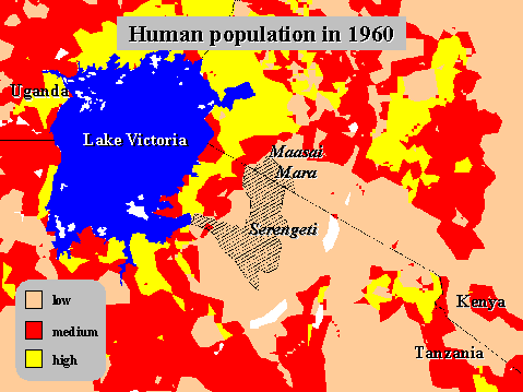
The population of Africa is changing rapidly and, taking into account HIV and increased contraception, the population is expected to increase from 232 million people in 1960, to 1831 million by the year 2040. The striking thing is that the areas with the lowest population are the rangelands. However, by the year 2040, the rangelands that were interconnected in 1960 no longer are but rather have become islands. Where are the greatest conflicts between people and wildlife in Africa? East Africa is a combination of small and large parks – there are very few parks in West Africa. By 2040 East African parks will become isolated islands within a sea of humanity. Where is the greatest diversity of African Mammals? The highest diversity is in Africa and the crossborder areas. The highest pressure is therefore on the areas with the greatest diversity. Change is significant in the larger mammals. Below is shown the change in the number of species with the change in land use.
How have people and Wildlife Changed in the Maasai Mara?
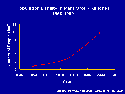
In 1960 the Mara was an open access system but the population model shows the Serengeti – Mara ecosystem is a closed system by 2000.
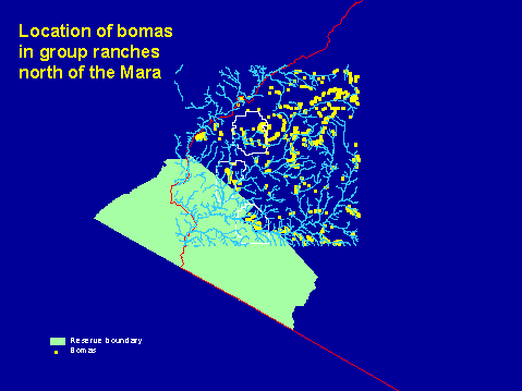
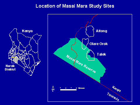
This area was defined by Richard Lamprey and was recently resurveyed by Reid, Rainy and Wilson. This shows directly where people choose to live and can be used to identify the future of Wildlife in the area. The graph on the right shows the population increase in the Mara group ranches there has been a per annum increase of 7% where as the national average for the country is 3.4 to 3.5%. How does this affect wildlife? By 1977 there was a patchy distribution of cropland. Between the 1970 and the 1990’s there has been an expansion of cropland from 7% to 45% by land area. There has in this time been a decrease of Thompson’s gazelle by 40%, ITC and DRSRS data from Wilbur Oticello also shows a 65% drop in the resident wildebeest population. Data from Rainy, Reid, Wilson and Harris – Wildlife, Livestock and Human distributions in the Maasai Mara. In April of this year, the field team conducted a high-resolution animal count in the Maasai Mara. This involved counting wildlife and domestic animals at a resolution of 11.1 hectares. This fine resolution counting using a GPS gives a very close spatial picture of wildlife/ livestock/ human interactions.
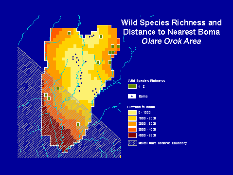
Within this, Aitong has more wildlife and Talek has more people. Olare Orok is in the centre of this continuum. The results of the high-resolution count showed that the distribution of livestock correlated strongly with boma sites. The distribution of wildlife is much more widely spread. In the Olare Orok area, wildlife is located away from boma sites, which was also the true of the Talek area. The amount of overlap between wildlife and livestock was only 1-2%. Wildlife and livestock rarely occur in the same area together. GIS distance from Bomas
Aitong, Olare Orok and Talek wildlife is distributed away from Bomas wild animal species richness therefore increases with the distance away from Bomas. The slide shows the mean diversity per block, which reaches a peak at about 3km away from Bomas. This could be a fact of predator avoidance, grazing facilitation or the fact that bomas are often located near water sources which means that the wildlife are staying near for access to the water. This is shown for two of the areas below. Why Worry?
H. Dublin: The story in West Africa was that the grasslands of Guinea had higher mammal diversity than we have here, yet these have decreased. There is a large amount of data cataloguing this decline. R. Reid: The model can be used address this. This sort data is a snapshot with the model; we can look into the past. J. Ellis: We are bound to fail to some extent, how can we prevent the West African situation? Other rangelands are depopulating. 25% of the rural US population has been lost in 10 years (not everywhere) leaving land for bison etc. Projects another 50 years of population growth before the US situation is realised here. J. Else: Uganda has precious little wildlife left. Wildlife areas are just islands with no mature systems. The projected increase will isolate animals in reserves what do we do, forget the outside? R. Reid: No, what we are trying to prevent is the stave in on National Parks. The rate of change has been more recent, but there is always a lag time to get to policy makers.
This presentation has three main points:
Although we have a possible 280 species when looking at mammalian biodiversity, as a tourist, there are really only a few possible species that you are likely to see here in Kenya. If you compare East Africa, Southern Africa and Northern Africa, we have the most mammals here in East Africa. North Africa has a tourism industry independent of wildlife. The pocket economist shows that we are not in such good shape here. The population density here is 45 whilst that of southern Africa is 15 and we are not urbanising as fast as South Africa (57). Unfortunately for us from a tourism perspective we have many of the same animal species as South Africa. Certain species such as Sitantunga, Bongo, Greater Kudu, Roan and Sable are at the northern extent of their range in Kenya. Grevy, Gerenuk and Oryx are all dry land animals of the horn of Africa. All these are interacting very poorly with domestic livestock species. If we do not do something, we will only have 12 species that tourists regularly see and not the 23 that they seen now. As a result, East Africa could fare poorly in competition for tourists dollars with South Africa. Rapid Monitoring – a Test in Amboseli The technique that we used for counting can cover 40km2 in a day’s count. Spread over 3 days, we could provide a snapshot of biodiversity for Arab Rocks, the edge of Amboseli National Park, the Park, Kimana boundary and Kimana sanctuary. We concluded that there are great differences in animal biomass among locations. There are fewer people and cattle in the National Park. However there is a lower number of animal species. The variation in total biomass is explained by 2-3 species. ? Wildebeest and elephants make up 70% of the biomass. Further east, we encounter wetter terrain. To gain species, one has to go outside of the national parks, e.g. to Kimana sanctuary. In this way we get a wider variety of habitats. The trade-off is that there is a drop in biomass as there is a higher human population outside the park. The studies show that we have very sharp edges around the protected areas in 1999. But what about 10 years from now? Is it wise to have biogeographic islands that are so polarised? To demonstrate the effectiveness of simple monitoring, we organized a simple, low-cost monitoring program of wild dogs in central Kajiado. Recently, packs of wild dogs have appeared in the vicinity of our tourist camp. At the same time, this foot-monitoring program identified potential security problems in the area, particularly through sightings of Shifta and evidence of raiding. (A report was passed out with this information ) M. Coughenour: Clearly we need to develop a better understanding of why animal numbers have declined in Kenya, and the extent to which these declines might be the result of increases in livestock, overgrazing, habitat fragmentation, poaching, poor land use planning, or other causes. This understanding must be built into the model. P. Mohlmann: These results show that while protected area status solves some problems it often results in a different set of problems. Thus, protected areas cannot be seen as the sole solution to wildlife conservation. J. Ellis: What is going on outside of Kimana Sanctuary? M. Rainy: This is an area of cultivation, although the sanctuary is based on the border of 2 group ranches which have dry season access to the papyrus swamps. These swamps were set on fire in December and are still burning because 2 group ranches failed to agree over a common use plan. As a follow-up to this, it is clear here that pastoral existence does not have any major negative impacts on wildlife, but cultivation does. However, people turn to cultivation to keep up with the population increase. We need to decide the most effective and salable way to reduce this pressure for cultivation.
KWS research activities especially in the Mara ecosystem, address the issues of land use changes and policy impact in the Mara ecosystem. KWS acts as the custodian of wildlife in Kenya but in addition in the Mara, KWS acts as security for tourism and wildlife, conducts research, and advises on the management of the Maasai Mara. Research 1991 – Policy framework formulated. By the late 1980’s we had experience with revenue sharing (among the Reserve and local people) 1995 – Wildlife policy was revised which then looked at biodiversity and tourist revenue. 1996 – Savanna Land Use Policy Outcomes project initiated – interested in integrating land use policy analysis, socio-economics, demographics, GIS, and remote sensing for the Greater Serengeti. This is a collaborative project between KWS, University of Dar es Salaam (IRA), University College London (K. Homewood), and Catholic University in Louvain, Belgium. Ecological Monitoring – elephants and buffalo with Friends of Conservation and WWF – found that land use policies explain the land use changes with the time span in blocks (1960 – 1970) KWS study area – the Mara covers 1530km2 with the adjacent areas of the National Reserve, Koiyaki, Lemek, Olkinyei, Siana and Olchoro Oirua. The tenure of this land differs; the reserve and Siana are held as trust land, Koiyaki, Lemek and Olkinyei are group ranches, whilst Olchoro Oirua is privately owned land. Trends The group ranches can be regarded as the buffer zones of the Mara ecosystem. Analysis of satellite pictures from 1975, 1985 and 1991 show an increase in extensive wheat farming and small-scale farming and a decrease in the amount of shrubland and forest. The decrease in the shrubland is an effect caused by the amount of large-scale farming. Between 1975 and 1984 there was a large southern expansion of the wheat fields, which brought about problems with wildlife control. In 1981 there was a World Bank project where they constructed a game fence, but the wheat farms spilled onto the other side of the fence. In 1993 the fence was pulled down and relocated. More recently the wheat farming has expanded right down to near Aitong DRSRS wildlife and livestock trends between 1986 and 1996. There has been a rapid decline in giraffe, Burchell's zebra, warthog, topi and wildebeest. There has been a moderate decline in buffalo, kongoni and eland. There has been slow decline in Impala and Grant’s gazelle. Elephant, ostrich, cattle and shoats have been stable in the system whilst there has been an increase in donkey populations. KWS and FOC have been doing total counts between 1988 and 1997. These have shown that between 1988 and 1992, there was an increase in buffalo, but there has been a decline since 1992. Elephant numbers throughout this period have been stable, between 1991 and 1996 Elephants were found outside of the Mara ecosystem area, which was attributed to increased security. In this period of time, buffalo numbers on the Nguruman area of the ecosystem have been down. In the period since 1969 the human population has increased from 125,000 to 200,000 in 1979 and further to 400,000 in 1989. This increase in human population has been attributed to the immigration of people. This has had a subsequent effect of changes in culture, which has seen a house building change with corrugated iron houses on the increase above traditional houses. Way Ahead Trends in land tenure and land use policy has lead to a further decline in the wildlife options:
Landuse models that address the following questions are needed:
R. Estes: Why was there such a drop in buffalo? A. Kariuki: Probably poaching as most of the poaching occurs outside of the reserve, but most of the buffalo is outside of the reserve. M. Koriatah: There was also a significant drought in 1993 and 1994 which could have played a role. There was also a decline in buffalo in Tarangire and Serengeti. The exact cause of the decline in buffalo in Serengeti is actually not known. There has been no buffalo meat recovered from poaching camps. Buffalo are now increasing. J. Mworia: Tp what would you attribute the increased use of corrugated iron as a housing material. A. Kariuki: Several reasons, economic empowerment, and exposure to other cultures and status symbol. M. Koriatoh: The Talek area tends to have permanent, semi permanent structures on their own land. It highlights the settlement of people from a more dynamic existence. M. Rainy: This is also a reflection of the sedenterisation of the settlement pattern. J. Mworia: Who is doing the extensive wheat farming? A. Kariuki: The land is leased out to outsiders of the system. J. Ellis: Is there any speculation about the implications for the rest of the system? A. Kariuki: Some of the monitoring programs will address these issues. D. Estes: A book by Herbert Prins addresses the issues of sub-population decline in the Lake Manyara Buffalo. P. Mohlmann: There may be an expansion of shrublands in response to a form of anthrax that affects impala, so there is therefore no browsing pressure on small Acacia; there may be an explosion of the bushlands. J. Else: The PARC program has not picked up type II rindepest that is less virulent, but it is possible that this rindepest is contributing to buffalo mortality. As it is not so virulent, the animals appear not to be infected, but are weakened and are dying of other causes.
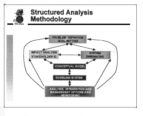
SAM is a formalised protocol to help people work through complex issues and to solve problems pertaining to natural resources management. It is especially suited to address problems involving multiple stakeholders in a common resource base. This is one of several protocols that have been developed in this area. Ecosystems are people within communities acting with land and water. The definition must include people, as human demographics are very important in shaping the landscape. As many ecosystems are modified, why should we worry about a natural ecosystem when we have very few.
Preservation is a definite land management process, were activities are done to improve the quality of life e.g. food production etc are the intended results of the improved quality of life, often when we try to improve the quality of life, it has unintended results.
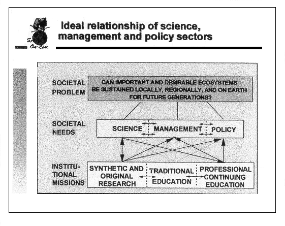
There are 3 important needs in the process; Science, Management and Policy. In reality, these are three ‘solid boxes’ i.e. separate entities. SAM aims to make these boxes as ‘leaky’ as possible, allowing the exchange of information. If we can achieve this, then we have institutional missions with filtered down information from the societal needs. This also shows the how important original research and synthetic research is in influencing policy making. Problems in reality exist in a hierarchy of spatial scales, temporal scales and the relationship of social societies. SAM utilises new and traditional approaches to address these problems on these scales. Different people view the system differently; i.e. it is a system defined by many different viewpoints. For instance a developer may not see the system in the same light as an ecosystem scientist. It is therefore vital that as many people with differing viewpoints be brought together in the SAM process. SAM is not a decision-support system – it will not solve problems itself, but the groups participating will. Instead SAM can be thought of as a tool of probing questions and group generated answers. SAM is also guided collaboration. The SAM framework emphasizes the need for complete analysis by creating clear problem and goal statements based on the careful evaluation of space and time scales, thoughtful impact analysis, conceptual model building and finally environmental planning and monitoring. These steps are achieved through collaborative processes are designed to reach agreement among people (stakeholders) with differing viewpoints. This framework is seen as the linchpin of all collaborative activities.
Attributes of Group Success
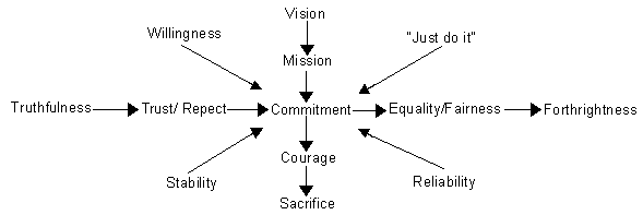
Vision: A better way to do something. Mission: What the group intends to do. Commitment: The group needs to be committed to see the process through. Courage: Often requires personal courage to do it – often options are unpopular. Sacrifice: Something may have to be given up during the process to achieve the goal. It is very important that there are no "hidden agendas". If these show up then the process is bound to fail. Trust and respect do not necessarily mean that you have to like a person. Both of these qualities are possible without friendship. Equality/Fairness are essential in the process, because if somebody has had to sacrifice something in order for the process to work, studies have show that if the person feels that it is fair then they are more likely to make that sacrifice. When the group is successful then the group assumes its own identity and a feeling of "just do it" prevails. R. Reid: Is the question of needs and wants the full question for East Africa? Maybe the broad question is an innate question to the system (e.g. hunger) B. Woodmansee: No, certain needs must be met, after you have met those then you can address the questions. W. Mutero: Is competence not an integral part of the system? For example, what if somebody has been sent from an institution but does not specialise in the subject? B. Woodmansee: No, competence is not necessary as it can develop through the process. "Competence is like ignorance - it can be corrected"
Ole Kamuaro Are there desirable ecosystems? What are they? Yes, we know they are the viable, life-support systems that we have long depended upon. What is lacking is concerted effort to ensure their continued viability. Now, many decisions are made on policy whims rather than reality. Decisions are being made for the wrong reasons. There is a need to get information on the right choices to the right people.
USAID/Tanzania is funding AWF to conduct the Partnership Options for Resource Use Innovation (PORI) project. Its objectives are to support tourism, infrastructure, community outreach, and planning. As a result local communities in around Tarangire and Manyara National Parks in Tanzania will increasingly benefit from wildlife conservation The area encompasses some 37,000km2, of which Tarangire and Lake Manyara National Parks make up just 2600km2 and 230km2 respectively. The majority of the area therefore consists of local communities. The project has adopted a "complex" (or "heartland") approach that recognizes a diverse landscape consisting of core protected areas and surrounding lands which sustains both biodiversity and people in the face of uncertain change. The vision for the Tarangire – Manyara Complex is to "maintain a rich and continuous mosaic of landscapes, wildlife and human benefit from the Rift Escarpment through the baobabs of Tarangire to the Maasai steppe". PORI’s activities in the area include:
The 1988 census showed that there were 445,000 people in the TMC area, 80% of which were pastoralists. The wildlife populations for the TMC in 1994 are:
The estimated numbers and density of Livestock and Wildlife in the TMC in 1990
(Source TWCM 1990) Livestock/ Wildlife interactions Studies in the Simanjiro Plains in the 1970s indicate that while wildlife use the area during the rainy season, livestock use it more during the dry season. The estimated biomass density kg/km2 of large herbivores in the Simanjaro Plains (570 km2) is as follows:
One of the major problems is that we have little information of the areas outside the national park. This is where we can envisage the use of Savanna.
The Ministry is not merely participating as an observer; it sees itself as a major stakeholder. The ministry itself rarely carries out any research, but rather is tasked to develop policy and develop government technical advice. The Ministry is relatively young; it is only 2 years old. Formerly under the Ministry for Environment and Natural Resources, the Ministry of Environment and Conservation was born out of a cabinet reshuffle. In its former setup, it was called the Department of the National Environment Secretariat formed in 1974 under presidential decree in response to the Stockholm meeting. The aim of the secretariat was to have a forum which it could articulate its natural resource policy. The Secretariat had its own organisational structure which was partnership orientated which meant that it could work with other institutions e.g. KWS/ DRSRS. The secretariat facilitates between these all and contributes to their activities. It serves as a focal point for:
The ministry is now focusing at a community level. A study carried out between Nov. 1991 and April 1992 was the first attempt to identify Kenya’s biodiversity and to identify areas that required conservation. The study aimed to
Biodiversity Information and Data Management This forms the basis for making decisions even at a national level and to assess institutional capacities in their abilities to organise data and streamline that data collection. The output of this was in the form of:
National Level Activities The Ministry has a current project through UNDP that aims to reduce the loss of forest and wetland biodiversity in cross-border sites. Local communities – balance resource demand and supply through local cross-border stakeholder demands. To date there has been a 1-year period where the groundwork has been laid; this has been used to identify the sites on which to focus. The way forward is to involve local communities, as they often become isolated in programs and the programs then become unsustainable. Perspective: As we develop the Savanna model, communities should be involved from the start, people are a part of nature, not separate from it. The focus should be on the dynamic picture.
This is a forum by which wildlife information can be shared between both countries. The Serengeti-Mara ecosystem faces 4 primary issues for trans-boundary ecosystem management:
The Serengeti-Mara ecosystem composed of parks and other protected areas such a Loliondo and Maswa Game Control Areas. In total the system is 40,000km2 as was identified from the aerial surveys of wildebeest migrations. These animals move in response to forage and water availability, but the whole area is surrounded by pastoralists and transhumants there is therefore bound to be domestic-wildlife conflicts. The western side of the NCA is now intensively farmed and within the Ngorogoro there are places where agriculture is allowed. The wildebeest population is now down to less than 1 million, why is this? We need to know what is happening on the Kenya side of the border. Wild dogs are also know to cross the boundary between the systems. Why are there population declines in buffalo (discussed earlier), roan, sable and oryx?. There is also an issue of the rindepest problem, but not restricted to this we also need to know about rift valley fever (RVF) and foot and mouth disease. Cattle rustling is a significant factor in the spread of disease. In 1990 a gift bull was received from a Maasai in Kajiado, but within 2 years 22 districts were infected with capri-bovine pleuro-pnemonia (CBPP). Soitsambu was the entry point and this spread all the way to Karima district. Migratory bandits and rustlers steal cattle south of the Serengeti in Sukumaland and walk them north. The solution to this is to normalise trade across the border and to control vaccinations on both sides of the border more effectively. The Kenyan and Tanzanian Maasai are brothers, and have a relationship such that political borders are not essential for their survival. There is a need to provide a capacity building environment to interpret scientific findings and develop the capacity for people to monitor change for more effective planning. A mode of information exchange should be developed between stakeholders. The key problem for the management of all resources – we are concerned with the local people and illegal utilisation of resources, we need to address the needs of local people. Outreach programs at TANAPA address people’s needs where livestock needs are taken seriously as wildlife can coexist better with wildlife than any other form of land use e.g. Intensive Agriculture. It is important to realise that there are other important ecosystems such as the Amboseli – Kilimanjaro ecosystem as the forestry projects on Kilimanjaro act as an important water source for Amboseli. If this is interfered with, then Amboseli will no longer be a sustainable wildlife ecosystem. In this case, Arusha National Park has already been excluded from the system. The Tsavo/Mkomazi ecosystem is another system that is seeing increasing human pressure. Ole Kamuaro – The profile of Savanna needs to become more official than it is now. Hopefully the cradle of mankind can be the cradle of effective monitoring. However, I note that the model does not address security, which appears from the presentations to be a very important consideration.
The Savanna model could fit well into our work in Uganda. Our study area consists of the Lake Mburo National Park and the adjacent cattle ranches. The total area is approximately 540km2 with the Adjacent Ranching Schemes (ARS) making up 280km2 in a semi arid area with average annual rainfall 700 –800mm in a bimodal pattern. The vegetation was originally Acacia-Themeda savanna but Acacia hockii and Cymbopogon nardus now dominate the ranches as a result of overgrazing and cold, rather than hot fires. The animals that are commonly seen in the area are impala, zebra, warthog, eland, hippo, buffalo and topi. Conservation History This area was settled by Hima pastoralists 400 years back. At the start of the 20th Century, an outbreak of Tsetse fly and trypanosomiasis led to the flight of the cattle keepers and a corresponding increase in the wild animal populations. In 1933 the area became a controlled hunting area and in 1950 a tsetse fly control and eradication program was established. In 1964 a USAID project set up cattle ranches and the remainder of the area was declared a game reserve. In 1982 the area was declared a National Park with the pastoralists forcefully evicted. In 1990, 2 square miles of land were set aside for resettlement of the community – a total of 851 households were resettled. From 1990 there has been an invasion of agricultural communities on the northern side. The following management issues of the park create conflicts:
The solutions to this are:
Savanna is therefore timely and an appropriate model to explain the dynamics of this system with respect to these solutions.
I would like to highlight the issues/ problems faced by people in these areas. The NCA comprised 25,000km2 of the Greater Serengeti Ecosystem, as defined by the migratory extent of wildebeest. Surveys in May 1998 and April 1991 showed that there are approximately 191,000 zebra, 355,500 Thompson’s gazelle, and 1.2 million wildebeest in the GSE. The NCA is an example of multiple land use. Other parts of the system differ. The Serengeti National Park is set aside for the non-consumptive utilisation of wildlife, whereas in the Loliondo Game Control Area, all forms of utilisation are permitted. The Maasai-Mara Game Reserve in Kenya is run by both the County Council and the group ranches. In each of these areas there is potential for livestock – wildlife interactions to occur, there is also the potential for disease transmission to occur. The potential for IMAS is therefore great here. Disease significantly affects both livestock and wildlife – particularly rinderpest and MCF. In the case of Rindepest, cattle are argued to transmit the disease to wildlife and vice versa. The consequences of which are that livestock are reduced by disease, decreasing the livestock to human ratio greatly, which results in poverty. After the eradication of rinderpest, there was a 400% increase in the wildebeest population to 1.4 million. It has been argued that this has prevented pastoralists from using the short grass plains during the wet season which, during the wildebeest calving period. Pastoralists cannot use the low-lying plains between January and March. There has therefore been an expansion of range and time of occupancy by livestock at higher elevations. This has disrupted the traditional rotational grazing system, and led to further displacements of livestock to other pastures. The consequences of this displacement is that the highlands are getting longer annual use, leading to overgrazing. Hence, starvation mortalities increase. Cattle are more likely to have yearlong exposure to ticks, which results in more tick-borne-disease (TBD) mortality, leading to further increases in the human/livestock ratio. The diversification of economies in the area thus results in a vicious cycle that results in cultivation, a further decline in cattle numbers, and a need for more cultivation. This poses a great threat to food security in these areas However, the pastoral rangelands are also an important dispersal area for wildlife. The Savanna model needs to balance this complex set of needs. In order to advise ecosystem managers, all of these factors must be considered simultaneously by the model. M. Lemay: Were rinderpest vaccinations a mistake then? T. Mlengeya: They were essential to improve the trade in animal products but now there are other diseases. It is acceptable to control MCF. The rindepest vaccination campaign was a global campaign to improve the animal product trade but now we have other diseases that pose a challenge. M. Coughenour: Rinderpest was an introduced disease – does anybody know the wildebeest population was before the introduction of rinderpest? A. Talah: There is no evidence in the literature about the population in 1890 when the 1st introduction of rinderpest occurred. Wildebeest must have been kept low while rinderpest was prevalent, until 1960 when rinderpest was finally eradicated through the vaccination of livestock. M. Coughenour: The number of wildebeest before the eradication of rindepest was 250,000, however for the model, we need to establish a benchmark value for the wildebeest numbers. In other words what is your status quo – before or after the introduction of rindepest? It appears that the alleviation from rinderpest is causing an increase in the population, but using a rinderpest-controlled population as a benchmark for a pristine ecosystem seems fallacious. R. Estes: Although you have mentioned the human: livestock ratio, you have not mentioned the increase in human population. Do you know the current human population of the NCA? A. Talah: The last census in the NCA in 1994 was 42,000 people, there are no current figures. R. Estes: What has been the estimated population increase in this time? T. McCabe & P. Mohlmann: The increase is estimated to be a doubling or a tripling. M. Parkipuny: There is local community involvement in Kenya but not so much in Tanzania - What is the problem? If we have a local market, then why are people not learning? M. Coughenour: This is the first mention that we have heard of the human to livestock ratio being actively managed. What is limiting the ratio? Is it due to livestock disease? T. McCabe: Livestock sales and disease of which disease probably has the greatest effect. P. Moehlmann: The lack of forage forced the cattle into the highlands creating a higher mortality due to TBDs. R. Estes: Does this not have to do with Maasai land utilisation i.e. on the eastern side they have been excluded up into the highlands where they have been exposed to TBDs. T. McCabe: Yes, this is a valid point.
Science and scientific collaboration with stakeholders is necessary if not essential for the ecosystem. The Savanna model needs to provide the stakeholders with information to improve their decision making. Stakeholders from the grass roots are few here, yet it is their land that we are discussing. On 9-10 December 1992, the United Nations hosted representatives of the world's indigenous peoples for the first time. They found many categories of people with very distinct cultures. Stakeholders and the process of empowerment of local people were agreed to be essential But when indigenous peoples have tried to discuss these issues with non-indigenous people in the past, they have been met with skepticism and silence. The problem is to get indigenous people heard. The indigenous people who have long been on the land must be considered. Their rights and land have repeatedly been taken away, throughout history. In Yellowstone,, the U.S. government "took the prize" and "left the rest". At a 1973 conference on caribou management in Greenland, indigenous herders received condescension, skepticism, paternalism, and silence. I was sent to the U.S. in 1975 to learn to be a manager of a USAID livestock development project in Tanzania. I was to learn to herd like U.S. cowboys.. Instead, I went to a Hopi/Navaho reservation and found that these peoples had been treated similarly to the Maasai. The lesson was, you cannot make American cowboys out of Maasai or American Indians. This is not a question of participation, but of decision-making power. Participation (in an externally imposed process) is not sufficient. The decisions must be those of the land owners. Thus, the IMAS must be driven by local people and their knowledge. D. Evans: The perspective is important, all farmers can be regarded as scientists as they provide new information and are constantly looking for solutions to problems. Reality is a problem and a solution cannot be found quickly, so we are bringing information for indigenous people to use. What are your problems so that we can help you? Ole Kamauro: The adaptability of the model to local conditions deserves a level of skepticism. M. Rainy: That we are using information that is backward is something that I would argue with. We are seeing the impoverishment of people. It takes a while to realise that this is the first time that the living system is hitting an iceberg. The efforts have to be joint, we cannot afford to bicker when there is no time. We do not have a historical precedent for what we are all facing.
I work in collaboration with Prof. Mbogoh of the University of Nairobi and have done field work in Amboseli on the socio-economic interactions between people, wildlife and livestock. If these groups are sharing the same resources then there is bound to be conflicts. We have seen is a large land transformation that has reflected how rangelands can be used. The World Bank through the group ranches has transformed the land tenure of the Maasai. The idea behind this was to progressively induce change from communal to private ownership of land. The results have affected the survival of wildlife and domestic livestock. There has been a correlation between the size of land units and the number of domestic animals per land unit. Two weeks ago, the team visited 2 Group Ranches in Amboseli: Kimani and Mbirikani. Both have many wild animals and when the animals come there are lots conflicts with human activities, particularly cultivation. A Recent History of Human/ Wildlife Conflicts in Mbirikani 1996 – 50 Goats, 37 Sheep, 8 Cows, 8 Donkeys killed by lions and hyenas. 1997 - 340 goats, 110 sheep, and 140 cows killed. 1998 - 200 goats, 50 sheep and 40 cows killed by lions, hyenas, elephants and cheetah. This is happening because the land is individually owned. KWS has paid 1-2.5 million shillings in compensation. The compensation was a benefit for the people. A difficulty arises from the direct payment by the government as the funds are often inadequate. Benefits come and go, but the costs remain. The Benefits. Tourist lodges benefit the community through jobs, rent, and equity. Communities have sanctuaries too. People can rent out land to somebody and anybody can go there to rent a campsite. The Costs. However, the costs are borne differentially. Costs of pasture – animals that spill over from the national park utilise the rangeland that is used for domestic grazing. Elephants also destroy crops grown in the areas. The fences in the Amboseli area have solved the problem for a few people, but have simply changed the areas to which the elephants migrate to and this has just passed on the problem on to other communities. Wildlife also kills people. There is now no compensation if destruction takes place. There was 30,000 shillings per cow but this was stopped after people abused it – there is now no compensation. Costs are borne by individuals whilst the benefits are shared by groups of people.
Goals of the breakout groups are to produce:
Group 1: Problem Statements
The potential outcome from both of these is insecurity. Group 2: Problem Statements
Group 3: Problem Statements
Group 4: Problem Statements
The objectives here are to model as realistically as possible the three important livestock diseases of the NCA; MCF, rinderpest and East-coast fever (ECF) and to ensure that the resulting disease sub-model is compatible with Savanna. Malignant catarrh fever (MCF) is a disease carried by wildebeest with no ill effect. A significant fraction of wildebeest calves are infected at birth, and the rest become infected. The disease is expelled in mucous secretions by calves, which are born in the NCA with a peak in April. The cattle become infected through contact with plants and there is a near 100% mortality within infected cattle. Hence the Maasai actively avoid the areas where wildebeest are calving. Parameters used:
Overlaying cattle and wildebeest distributions in April show a low density of cattle in the central band of the NCA where wildebeest calving takes place. High numbers of cattle are seen in the highland areas in the east of the system, however here the population is exposed to ECF. The model also returns an output showing the cells in the model where there is a least one infected animal. The on going work in the development of the disease model includes the following:
Q: How do you estimate the infectiousness of the wildebeest? R. Boone: This is a parameter that is being developed, I would pass this question onto Jan Grootenhuis J. Grootenhuis: An infected wildebeest calf was put into a group of 60 cattle and the rate of transmission was analysed. Also, in research at Kabete a herd of pregnant wildebeest was mixed with cattle. This was how the transmission of the disease through the mucosa was discovered. P. Moehlmann: How long does the disease last on the grass? J. Grootenhuis: The disease lasts approximately one hour on the grass in direct sunlight but can persist overnight without direct sunlight. P. Moehlmann: Therefore within 2 days of the wildebeest leaving the area, it becomes a viable grazing area again. J. Grootenhuis: Yes. J. Grootenhuis: The model assumes that the peak calving is in April can this be changed? The disease peaks about 1 month after calving which lasts about 1 month. Research on Hopcraft’s ranch has shown that the duration of outbreaks is 1 - 2 months. R. Boone: A lot is known about the time. For simplicity, the Savanna model uses a single month during which the calves are born. The disease model is not restricted to this but rather has wildebeest calves being born throughout this period. J. Grootenhuis: The period of calving in the NCA is narrow. In general the period of calving tends to be narrow within resident populations of wildebeest. However, in Amboseli there seems to be a wide variety of ages. R. Estes: 80% of calves are born within a timing of 3 weeks although this depends on slight differences in microclimate of the NCA. After the peak calving however, calves can be born up to 6 months later. It is not uncommon for calves to be born in December.
What are the effects of drought on livestock, wildlife and range quality? The method to do this is to impose a 2-year drought on the model by decreasing the rainfall in the period 1982-1984 by one third.
During the drought simulation, the model keeps track of the following plant variables; total above ground biomass, herbaceous green leaf biomass and total net primary production (ie. plant growth, NPP). During the drought period NPP declined compared to the control model simulation. The difference is shown in orange between the curves. For the animals, the model keeps track of the livestock populations, the populations of selected grazing wildlife (wildebeest and antelope), selected browsers (antelope and elephant) and the cattle condition indices. Selected results of this are shown below.
Under drought conditions there was a decline in the population of both cattle and sheep and goats. There was a general decrease in wildlife populations and a potential change in Elephant distribution. Condition indices of cattle in the control model are doing okay but decrease in the drought. A density dependent response is noted as the cattle population declines during the drought, there is more forage of better quality, therefore the forage condition index is higher for some years after the drought. Conclusions Under the two-year drought: 1. Range condition declined.
2. Livestock Numbers declined
What are the effects of increasing the numbers of livestock on the NCA? The method used to investigate this is to increase the number of livestock by 125% and 150% Augmenting the population by 125%
The results are that all of the other groups decline except shoats and livestock. Both grazing and browsing Antelope decrease by 7% and 9% respectively. Augmenting the population by 150% If the values for these species are set at a 150% of the current value, what are the effects on the system?
Herbaceous green biomass declines as shown on the left. Unlike the drought simulation, this loss is constant and does not recover to its former level prior to the augmentation of the numbers. There is also a large increase in unpalatable species. With livestock populations up by 150% there are 170,000 cattle in the system and almost 300,000 shoats. Both types of antelope show large population decreases. Wildebeest, zebra and buffalo showed a slight decline. Giraffe showed no change. What are the effects of improved veterinary practices on livestock off-take?
The effects that are noted are that newborn survival is higher and therefore people have animals to sell. The ability to take off livestock from the system mean that people have cattle and goats to sell during the wet years and that there are no surplus animals in the system during the drier years. Livestock populations also then do not fluctuate as much. The same is also true if adult survival is increased in the same way. How would making additional areas available to livestock affect their populations and the wildlife populations?
The results show an increase of cattle and similarly shoats from the control model. Analyses of the condition indices of livestock shown and improvement in condition. The grazing reserves formed by the craters offset the loss of condition in the dry periods. Remove the threat of livestock threat
The removal of livestock theft results in an increase in cattle but a decrease in shoats. All other species of wild animals show a slight decline but Elephants and Rhino show a large decrease in number by 13.9% Remove the MCF avoidance by the Maasai
The removal of MCF avoidance by the Maasai results in an increase in cattle numbers. There is a decrease in the number of sheep and goats due to a niche overlap between the cattle and the shoats. Ordinarily the shoats have exclusive use of the MCF band. There are also a greater number of cases of MCF. Removing MCF avoidance also caused an overall decline in wild animal numbers. How would additional water sources in the area affect Livestock and Wildlife? Turning on the failed water sources in the model can simulate this.
Making additional water sources available to livestock and wildlife results in a moderate increase in cattle numbers (+1.6%) but a decrease in the shoat numbers (-9.0%). There is also a change in the distribution of these animals. How would dedicating water sources to the lodges affect livestock and wildlife?
The dedication of water sources results in an increase in cattle numbers (+2.9%) but a severe decrease in shoat numbers (-8.3%). There are significant changes in herbivore distribution. What effects may the anticipated human population growth have on livestock and wildlife? Add households to the landscape with associated agriculture based on where people currently live. This is using a 3% annual growth. Then from 2000 projecting onwards the number of hectares under agriculture are shown and the number of households (assuming 10 people per household)
The spatial distribution for January is shown. Modeled agriculture from 0.5% of land area of the NCA to 5% = 50,000ha.
% Under agriculture Area cultivated (ha)
The consequences of this increase in agriculture is a loss in all animal numbers, especially wildlife Future Developments A training session has been provisionally scheduled for May 2000 and will address the following points:
T. McCabe: How close is the NCA to carrying capacity? R. Boone: This is modeled for carrying capacity, if forage increases then livestock will increase, the idea was to keep the control model with as flat as lines as possible to show stability. J. Grootenhuis: Should the model not separate for sheep and goats? R. Boone: I am aware that they are herded together but that they have different diets. The same is also true for zebra and buffalo but this will bring the model up to 10 functional groups and this will make it unwieldy. J. Else: can you use the model to establish quotas for off-take? R. Boone: Yes. J. Else: with reference to parks which are more island like, the model is straightforward for grazing animals but what about elephants and the destruction of trees e.g. Shimba Hills National Park which is fenced and the elephants are having a severe impact on precious forest. Is it possible to apply this to the model? R. Boone: Yes, definitely although not with the displayed parameters. The parameters are not flexible, however the model takes into account an animals browse height and that for elephants is set very high to take into account that they often take down the whole tree for leaves. P. Moehlmann: Does the model take into account the standing biomass into the following years from events such as El Nino? R. Boone: Yes, the model does take into account time lags but we have had more success modeling droughts. P. Moehlmann: What about fires? R. Boone: That is still pending to be modeled, at present they are lumped together as stochastic disturbances. J. Mworia: Can Savanna model continuous stresses to a system e.g. overstocking? R. Boone: Yes, recall the graphs under the control model – there was a horizontal line that was designed to keep livestock numbers constant analogous with permanent stress. The result was an increase in unpalatable species and a decrease in palatable species. J. Mworia: Does the model take into account human behaviour with reference to animal sales? For example, what if somebody chooses not to sell their animals even although they have a high condition index? R. Boone: There is a lag option for off-take. The results that were shown were set at immediate off-take for simplicity. M. Rainy: In reality, stresses do not happen separately, they are typically combined, and can the model take this into account? R. Boone: The effects are integrative, so all will change but it will be difficult to know which caused what. R. Reid: We realise that the model is not 100% perfect and it is a complex model. I presented the model to 300 people at the World Bank who specialised in rangeland research; they gave credit to the CSU team for the model. The 58 donors were also very impressed by the model, I am sure that we have undersold the model. A. Kijazi: In the integrated model, what happens with factors happening out side of the defined area? R. Boone: One always must define a study area. To take the wildebeest example, they migrate out of the system and return in lower condition P. Moehlmann: Does the model take into account when a water source actually dries up? R. Boone: The water sources that were modeled were purely those of discharge. F. Banyika: My concern is how many Kenyans and Tanzanians understand the model? M. Coughenour: There probably has not been enough exposure yet because
In the following years, there will be more involvement. M. Rainy: The model needs a user interface. It would be very difficult to understand if you bought this prematurely in its current form – it needs to be user friendly. Information does not recognise tribe, race or colour. J. Ellis: This is the exact question that we are asking on here on July 8th 1999. Mike Coughenour has developed the model over years in a scientific manner; we now need to move beyond this to get to the point where somebody without scientific training can apply it. This workshop is only a step in that direction but it is a big step.
Consequences of change Implementing a management strategy: series of questions that you can use to address particular groups of people, those questions complete the upper level of SAM Constraints: The whole workshop needs to choose one issue from all the issues proposed by groups in session I for further analysis. This issue should be:
Resulting Problem Statement: "Changes in human demographics and landuse are threatening the current Serengeti – Mara ecosystem." J. Ellis: I would like human welfare used instead. D. Evans: I would like to see cultural values in that statement. M. Parkipuny: I would like to see socio-ecological system in the statement. Revised Problem Statement: "Changes in human demographics and landuse are threatening the current Serengeti – Mara socio-ecological system. What is the desired ecosystem? Assumption is that the current ecosystem is the desired ecosystem. P. Bergin: assumption is that we start now, but ideally we would like to restore some of the ecosystem. F. Banyika: how far back do we want to go to restore the ecosystem? R. Reid: stakeholders buy in to the model then they can get to desired ecosystem. R. Estes: what needs to be restored in terms of vegetation and do we know the former vegetation? What ever we choose it would still be a system without Rhinos. A. Bornbusch: ecosystems are not static so a "desired state’ is an unrealistic assumption. Ole Kamauro: I would like to include ‘protection’ to the statement as I feel that we should continue to preserve present ecological function. The assumptions give us a driving force to go ahead. Way Forward Use the Savanna model and SAM to develop an integrated comprehensive land use and ecosystem management process with local communities involved in the development of these plans in a transborder region. One needs both of these (land use and ecosystem planning) to work together. This is unique and never has been done before. J. Ellis: We need an explicit statement of human welfare and economic development. J. Else: A land-use plan is political make-believe. M. Rainy: This is a problem in the whole of Kenya, but what we are doing has potential in an area as small as we are dealing with. A lack of land use policy is contributing to the loss of mammalian biodiversity according to a wide consensus of people. Therefore we need to start small and it needs to be cross-border such that we can deal with like-minded colleagues. J. Ellis: The idea of a plan has ‘baggage’ with it – he wants this to be a process. There have been instances in Kenya and Tanzania where a plan went nowhere therefore they need to rethink/ rephrase the statement. The whole process would be more successful if it was a person. Savanna is an interactive tool for planners and developers etc. The planner should not forget IMAS. Both sides are part of the plan, IMAS is continually assessing change in environment and the methodology is iterative whereas old land use planning was not flexible. J. Else: Ellis correctly points out that it is not just taking American knowledge and plonking it here, we need to look at culture. M. Parkipuny: Would like to see specific policy as part of the national policy of the two countries B. Woodmansee: Yes, the national policy in 2 countries must encompass this. B. Woodmansee: The objectives for the 2nd breakout group session are as follows:
M. Coughenour: Think of the process as a strategy of getting people involved – what actions do we need to take to get stakeholders involved.
Group 1: Redefined Problem Statement "Changes in human demographics and land use are threatening ecosystem productivity and diversity, human welfare and cultural values in the Serengeti – Mara ecosystem"
Develop a process for landuse planning and ecosystem management that is integrated, collaborative and comprehensive Group 2: Redefined Problem Statement "Changes in the intensity, type and distribution of human land use have threatened the integrity of the transnational Serengeti – Mara ecosystem inclusive of people, wildlife and biodiversity." The Way Forward Obtain the endorsement of enablers and participants of stakeholders to develop an integrated, coordinated and comprehensive land-use and ecosystem management process. (Landuse = the intensity, type and spatial distribution of land-use) B. Woodmansee: suggested that this be pulled together by a proposal development team A. Bornbusch: It is important to be clear about your definitions of wildlife and biodiversity. Group 3: Redefined Problem Statement "Increases in the human population and changes in land use are threatening wildlife and human welfare in the Serengeti – Mara ecosystem. This also has adverse implications for the national economies of Kenya and Tanzania." The Way Forward
Group 4: Redefined Problem Statement "Changes in human demographics and landuse are threatening target transboundary ecosystems and the people that depend on them." Points We are not focusing on the Serengeti – Mara alone We can look into on-going transboundary initiatives The Way Forward Provide access and training to decision-makers at all levels in the target ecosystems Result of the Process Decision making for ecosystem management and land-use is enhanced and accelerated by an integrated ecological model. B. Woodmansee: Why not focus on the Mara? T. McCabe: The model may be more appropriate for other regions e.g. the Amboseli ecosystem. B. Woodmansee: Problem, where are the stakeholders in the statement?
General Discussion B. Woodmansee: Why not focus on planning? J. Ellis: We wanted to focus on the problems and not the tool. D. Evans: Why use the integrated ecosystem model? T. McCabe: The model is a critical tool and thus was included. J. Else: We must include training in the program to have an impact. R. Boone: The focus was on model development and training, not implementation because the principle investigators are not from East Africa. T. McCabe: We need to identify stakeholders by office and not by individuals as the individuals frequently change. J. Ellis: We have a real dichotomy: Plan A is to get involved in the Mara – Serengeti and solve the problem. Plan B is to provide training so people can tackle problems better but it is not clear to me how to implement it. A. Bornbusch: What can the CRSP really do? It is modeling and monitoring and training. You need to join forces with the other elements to have an impact. Build those partnerships. R. Boone: Access to the model and training are guaranteed results. Ecosystem stability is not guaranteable R. Reid: It is important to clearly identify the ultimate impact or it will never be achieved. This will require mature thinking about linkages and clear establishment of those linkages with implementation partners. Ole Kamauro: The primary goal is to start dialogue on either side of the border. The first thing that we consent to is that we need to discuss these issues. This is what this will achieve; training is a by-product of this. We need people to manipulate land use – training then becomes an issue. M. Rainy: Plan B is a more realistic focus as we may be able to accomplish our goal in several sites, otherwise we may get swamped in too big a goal. R. Reid: The advantage of being very focussed is that you can afford to be very humble. It is very important to be humble and appreciative of what other people are doing, because we are new and many of the people on this project are from the outside. J. Else: Yes, the problem is being the ‘new kid on the block’ and therefore one must tread lightly. M. Coughenour: Training is not enough. We must have an impact on policy, what does Dan Evans think? D. Evans: These issues are very large. One of the things that has come out is the magnitude. This is a tool in the process of development and does not have a clear idea of the big picture. The model cannot work in isolation. Need to identify the logical partners, the logical scope of the partners. This is a powerful enough tool, who can fund this, as it is a long-term project. M. Coughenour: It is confusing to figure out what USAID wants. Do they want impacts on policy, or just training? We need to link up with other parts of USAID for implementation. A. Bornbusch: the CRSP team cannot implement the whole process. M. Coughenour: We need to identify partners in this large process. B. Woodmansee: We are all stakeholders on the process. A. Bornbusch: Don’t just look to USAID, Rockefeller Foundation, the MacArthur Foundation is shifting its focus from Latin America to Africa. M. Lamay: I like plan A because it is more integrative A. Bornbusch: Plan B is a sub-plan of Plan A, showing what the CRSP team can really do. M. Parkipuny: We now know will do the implementation – why can’t we take plan A and plan B together. If CRSP cannot do these, lets do them anyway. Let’s develop an integrative team to solve these problems. Ole Kamuaro: What is the next step? Lets adapt these problems (A + B) that we have identified and elect a proposal development team to take this forward. B. Woodmansee: Plan A and B can be integrated. I get the sense that some part of this on the ground and get moving. F. Banyikwa: If USAID is the funder, where is the development in the proposal? It needs to include poverty alleviation, empowerment and human welfare as goals. B. Woodmansee: Can we integrate these two problems (the group showed some consensus on this but it was not resounding) but now we need to identify the key stakeholders. J. Else: The problem approach is very generic. If we use plan B then the next step is to identify where you would apply this approach as case studies. The identification of stakeholders depends on where you want to implement the model. Where else would you pick to parameterise the model. D. Evans: Where do you have the information to parameterise the model? M. Coughenour: The new areas are Amboseli/ Kilimanjaro and Tsavo/ Mkomazi. J. Ellis: Serengeti – Mara is quite feasible. Kajiado will be done within a year.
The purpose of this session is to identify stakeholders, and partners who will need to be included for a successful integrated assessment of the Mara-Serengeti ecosystem.
Group 1 Mara Serengeti ACC led consortium for land-use planning Village Governments Loliondo Division Village Governments - Loliondo Division (East), Sale Division (East) Group Ranches conservation association Sale Division County Councils – Narok and Trans- Mara District Councils -Bariadi District , Meatu, KWS - Meatu District Campfire Conservation - Serengeti District KATO TANAPA Commercial Farmers TAWIRI Private Ranches – Olchoro Ororua Frankfurt Zoological Society Private Tourism Companies (Lodges) TATO/ ATO - tourism FOC (Friend of Conservation) Private Tourism Companies WWF EU Land Use Project GTZ – led land-use project Trans-Mara Local Community Based Organisations EU Land Use project University of Nairobi Il-Kirin Integrated Level Project Cross – Border East African Wildlife Society EU Land Use Project East African Co-operation (Arusha) Training Issues
Group 2
ACC: Mara/ Serengeti
Tanzania – Laibonok
Ministry of Natural Resources Research - DRSRS Tanzania: Natural Resources and Tourism, Wildlife Division Office of the Vice-President Research – TWCM
University of Nairobi Tanzania: TAWIRI University of Dar es Salaam Sokoine University CAWM Mweka
Group 3 Local communities Large scale farmers. Narok County Council, Ngorogoro and Serengeti District Councils plus all other district councils surrounding the Serengeti. Wildlife and Conservation NGOs Wildlife Authorities: NCAA, TANAPA, KWS, Ministry of Environment and Conservation in Kenya and the Ministry of Natural Resources and Tourism in Tanzania Private Sector: Lodge and Camp owners and tourist companies Research Communities Donors Group 4 Tanzania Kenya Wildlife Dept/ SRCP KWS TANAPA Ministries of Environment and Conservation and Natural Resources NCA DRSRS TAWIRI Group Ranches Austropoject (Frankfurt) Community Conservation Agencies Maasai NGOs Mara Management Committee (ACC) Narok EU County Councils – Narok, Trans-Mara NORAD WWF DANIDA FOC GEF Campfire Conservation USAID GTZ District Councils USAID Amboseli/ Kilimanjaro Tanzania Kenya Wildlife Department KWS TANAPA Ministries of Environment and Conservation and Natural Resources TAWIRI DRSRS AWF Group Ranches Maasai NGOs Amboseli/ Tsavo Group Ranches GEF Maasai Group Ranches USAID Kajiado County Council District Council AWF – Amboseli Elephant Research Save the Elephants Campfire Conservation USAID Collaborators Kenya: AWF, ACC, DRSRS, KWS, County Council Officers Tanzania: TNRC (Tanzania Natural Resource Centre), Wildlife Division, AWF
Do you think the SAM process useful to an integrated assessment? Most of the participants agreed that the process was very useful. Did we meet the workshop objectives?
Ole Kamuaro closed the workshop and thanked those involved in the set up of the workshop. |