
Introduction


Developing a Multi-agency, Multi-scale Vegetation Sampling Program for the Central Grasslands
In 1989, the Board of Agriculture of the National Research Council (NRC) convened a committee to study how several Federal agencies (NRCS, BLM and USFS) inventory, classify and monitor rangelands (National Research Council, 1994). The committee stated that a standard method and a common data base for evaluating rangelands was needed. Traditional site classification methods based on potential or climax vegetation were difficult to use because of the inherent problems in the basic theories themselves. The classification problem was compounded by the lack of adequate inventory and monitoring methods to provide compatible data sets for multi-scale comparisons. According to the National Research Council, current rangeland inventories simply did not provide the data needed to support national assessments of rangeland health. We specifically addressed three of the five needs recognized by the NRC (1994) for a national system of inventorying and monitoring rangeland health:
The collection of data by the same or similar methods that will enable data to be combined on a national level;
The collection of data based on statistically valid sampling methods that allow evaluation of data at the site, state, regional and national levels; and
The need for repeated sampling to monitor trends.
Our goal was to work with clients and partners to develop a multi-agency, multi-scale vegetation sampling program for the Central Grasslands that met many objectives important to USDI land managers, the NRC, the scientific community, user groups, and the public. Our objectives were to:
Meet with clients and partners to identify priority data needs;
Test and quantify differences in commonly used rangeland sampling techniques; and
Develop a hybrid multi-scale vegetation sampling design to meet multiple agency objectives.
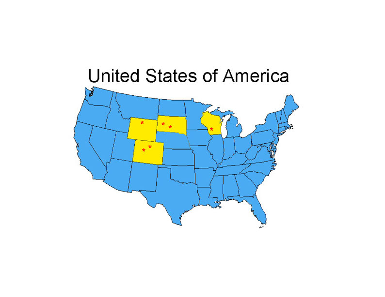
In 1996 four methods of vegetation sampling were tested and compared in four vegetation types in the central grasslands. These methods included:
The Modified Whittaker Vegetation Sampling Method,
The Daubenmire Method,
The Transect and Quadrat Method (NRCS), and
The Parker Method.
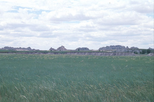
The four methods were superimposed in shortgrass steppe, mixed grass prairie, northern mixed prairie, and tallgrass prairie with 4 replicates in each type..
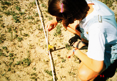
In 1997, eight Modified Whittaker Vegetation Sampling Plots were established in four research sites, for a total of 32 plots. Four of the eight plots were located in riparian areas and the other four were located in upland areas.
Information and samples collected at each plot included: UTM coordinates, slope, aspect, photographs, pooled soil samples, cover and height of plant species, cover of soil, rock, litter, water, scat, duff, identification of native and exotic plant species.
 Preliminary analysis included measurements of the status of
rangeland condition and patterns of native and non-native plant diversity in various
habitats with different grazing regimes on nine study sites in three prairie types
(shortgrass steppe, northern mixed grassland, tallgrass prairies) in the Central
Grasslands. Because the information was collected at multiple spatial scales, the
information was available for use immediately by clients to assess range condition locally
and regionally.
Preliminary analysis included measurements of the status of
rangeland condition and patterns of native and non-native plant diversity in various
habitats with different grazing regimes on nine study sites in three prairie types
(shortgrass steppe, northern mixed grassland, tallgrass prairies) in the Central
Grasslands. Because the information was collected at multiple spatial scales, the
information was available for use immediately by clients to assess range condition locally
and regionally.
In light of the above discussion, it is not surprising that all of our client agencies have ranked rangeland condition issues and the need for a standardized approach to this problem as high national, regional, and local priorities in the BRD Information Needs Process. For example, it is commonly accepted that in the Central Grasslands, and throughout much of the country (see the draft National Invasive Plant Management Strategy), invasive weeds are causing a decrease in native plant diversity and reduced viability of plant and wildlife populations. However, site- specific studies (e.g., National Parks, National Wildlife Refuges and BLM grazing lands) are woefully inconclusive and correctly criticized for small sample sizes, lack of replication, and poor standardization of methods. No two states or USDI units have collected information with the same field methods. A basic understanding of current range conditions and the effects of invasive weeds on native plants can be achieved only by statistically valid, systematic, well- replicated, multi-scale vegetation studies on a broad array of habitats and in areas with different land uses.
Principal Investigators: Tom Stohlgren, Kelly A. Bull, Yuka Otsuki, Cindy Villa, Michelle Lee.
Daubenmire,
R.F. 1959. Canopy coverage method of vegetation analysis. Northwest Science. 33:43-64.
Parker, K.W.
1951. A method for measuring trend in range condition in National Forest Ranges. USDA
Forest Service. Washington, D.C.
Stohlgren,
T.J., D. Binkley, G.W. Chong, M.A. Kalkhan, L.D. Schell, K.A. Bull, Y. Otsuki, G. Newman,
M. Bashkin, and Y. Son. 1999. Exotic plant species invade hot spots of native plant
diversity. . Ecological Monographs 69(1), pp. 25-46.
Stohlgren,
T.J., Kelly A. Bull, and Yuka Otsuki. 1998. Comparison of rangeland vegetation sampling
techniques in the central grasslands. J. Range Manage 51:164-172.
Stohlgren,
T.J., K.A. Bull, Y. Otsuki, C. Villa, and M. Lee. 1988. Riparian zones as havens for
exotic plant species. Plant Ecology 138: 113-125.
Stohgren,
T.J., M.B. Falkner, and L.D. Schell. 1995. A Modified-Whittaker nested vegetation sampling
method. Vegetatio. 117:113-121.
![]()
![]()
![]()
![]()
![]()
![]()
![]()
Contact the Multi-scale Team Webmaster with any questions:
last updated 11 September 2000