Research Objectives:
1) To observe and differentiate natural processes from unnatural, human-caused drivers of change.
2) To understand and quantify the effects of atmospheric deposition and climate change on high-elevation ecosystems.
Program Objectives:
1) To share knowledge gained from research activities with the public, scientific community, and natural-resource managers
2) To offer a program of graduate education and research that develops future scientists and knowledgeable resource managers.
3) To maintain the Loch Vale long-term ecological research project as a successful example of ecosystem-study design, interdisciplinary collaboration, long-term monitoring, and sustainable natural-resource management.
Biogeochemistry:
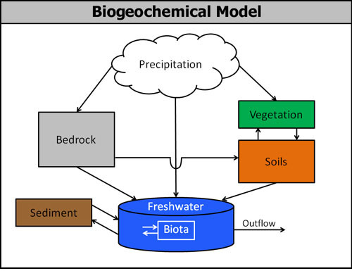
To understand the dynamics of one part of an ecosystem, one must also know about the system as a whole. Biogeochemistry is a systems science that studies the physical, chemical, and biological processes that control the composition of the natural environment. This research program is focused on understanding the biogeochemical processes of the Loch Vale Watershed. The figure below depicts a conceptual model of the Loch Vale Watershed study, and is followed by a brief description of each component.
Precipitation: The crest of the southern Rocky Mountains forms a continental-scale meteorological boundary, which influences storm trajectories and precipitation patterns. The southern Rocky Mountains are characterized by prevailing westerly winds. The major sources of precipitation at locations west of the mountain crest are synoptic-scale frontal disturbances bearing Pacific moisture. These storms lose their moisture in decreasing amounts from west to east on successive orographic barriers in their path. This type of storm is most prevalent during the winter months when precipitation falls as snow (~65-80% of Loch Vale moisture falls as snow with an average annual precipitation totaling ~110 cm). The spring and summer moisture patterns for Loch Vale are mainly influenced by easterly upslope storm events from the Colorado Front Range. These storms are a result of local convective activity east of the Continental Divide and have been attributed to the higher nitrogen deposition rates recorded along the eastern side of the Divide.
Vegetation: Loch Vale vegetation is typical of the subalpine-alpine vegetation throughout the Rocky Mountains, from central Alberta and British Columbia to Arizona and especially in the Central Rockies. Loch Vale forests are northeast facing, old-growth closed-canopy Engelmann spruce (Picea engelmannii) and subalpine fir (Abies lasiocarpa) stands at approximately 3,200 m elevation. The forests are characterized as cool, sheltered, well drained, with relatively deep soils. Limber pine is found on open slopes and ridgetops. Patches of krummholz (dwarf forest) are found above Timberline Falls. Forest covers approximately 6% of the Loch Vale watershed. Above timberline, alpine tundra vegetation takes the form of low, mat-like plants that are able to withstand the harsh, desiccating conditions that prevent tree survival. Alpine tundra vegetation occupies about 11% of the watershed area. Wet meadows are interspersed with forests in areas of low topographic relief along stream banks and bases of slopes, and cover about 1% of the watershed area.
Soils: Three soil regimes are recognized within the Loch Vale watershed: alpine ridge, forested, and alluvial/bog soils. Alpine ridge is confined to Thatchtop Mountain and the ridge above Andrew's Creek, with smaller areas above tree line in the basin that holds Sky Pond and Glass Lake. Forested soils are found in the valley floor below Timberline Falls. Alluvial and bog soils are restricted to a narrow band adjacent to Icy Brook and in one area of low relief adjacent to Andrew's Creek. Alpine ridge soils cover 11%, forested soils 5%, and alluvial/bog soils approximately 1% of the watershed. The remaining 83% of the Loch Vale basin is bare rock, boulder fields, surface water, or fields of permanent snow over boulder fields.
Bedrock: The Colorado Front Range is a north-south trending massif located in the central region of Colorado. The Front Range is a Laramide structure with a core of crystalline rocks made of predominantly Precambrian granite, schist, and gneiss. The core is framed by steeply dipping Paleozoic sediments. The metamorphic schist and gneiss, thought to be of sedimentary origin, are the oldest rocks in the range. Together with the Precambrian granites these rock types make up most of the terrain in Rocky Mountain National Park (Cole 1977). About 80% of the Loch Vale watershed is dominated by bedrock.
Surface Water: The surface waters of Loch Vale include lakes, streams, ponds, and temporary melt pools, although we focus our research efforts on lakes and streams. There are three major lakes within the Loch Vale Watershed (The Loch, Lake of Glass, and Sky Pond). All lakes in the basin are cirque lakes that were formed during Pinedale age advances of Taylor and Andrew's Glaciers. These lakes are all connected by Icy Brook, which originates at the base of the snowfields in the cirque above Sky Pond and leaves the watershed at the Loch Outlet. For stream and lake chemistry data, please refer to the data page on this website.
Biota: Subalpine and alpine lakes are generally low in phytoplankton abundance and lakes in the Front Range of the Rocky Mountains are no exception. Low nutrient levels and cold temperatures result in low productivity and biomass. Although a vast colonization pool of algae are present in the form of wind-deposited spores, only those physiologically able to withstand the low temperatures and extreme seasonality of light and hydrologic regimes are present in significant numbers. These and other physical factors exert a strong control on the composition and biomass of the phytoplankton community. In addition, ecological factors such as algal parasitism, nutrient competition, and food web interactions may influence phytoplankton populations (Canter and Lund 1968; Kalff and Knoechel 1978; Carpenter et al. 1985; Bird and Kalff 1986; Carpenter and Kitchell 1988). The most common phytoplankton in Loch Vale include Asterionella formosa Hass. in the spring and Oscillatoria limnetica Lemm. in the autumn.
Sediments: Prior to 1980 there was no systematic collection of precipitation for chemical analysis for the southern Rocky Mountains. Thus, we use lake sediment paleolimnological techniques to reconstruct trends in deposition over time from the mid-1800s to the present (Baron et al. 1986). Lake sediments are cored and analyzed for metals and diatom community assemblages. Sequential layers from the sediment cores are radiometrically dated to reconstruct patterns of metal deposition that could be attributed to an increase in industrial emissions. Diatoms have very specific pH preferences, which are well documented, so that knowledge of diatom community changes over time can be used to interpret lake chemical composition over time (Charles and Norton 1986).
References:


