 |
|||
|
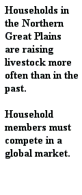
Ecology is the most dominant factor in land use decision-making in the Northern Great Plains. Ecological factors, including water availability, topography, and soils, dictate gross level decisions, such as whether to grow wheat or graze cattle. The economy is the second most important factor. Most agricultural production in the Northern Great Plains is for market, and much of it for export. As a result, farmers in this region are sensitive to market fluctuations at the national and international levels. This influences the choice of crops grown due to market prices for commodities, decisions regarding the use of inputs, and the consideration of household diversification strategies, including off-farm employment. Producers in the Northern Great Plains also depend on payments from several government support programs. Demography influences decision-making due to the fact that the population in many of the rural areas of the Northern Great Plains is aging and decreasing. Therefore, as the management of farms and ranches is being transitioned to the next generation of managers, there is the potential for altered land use decision making strategies and priorities. Likewise, the consolidation of operations due to operators absorbing, through sale or lease, the land of neighbors who are leaving the area, will lead to new decisions regarding land use management on larger acreages. Infrastructure, including water access, machinery, and transportation, is less important for decision-making in the Northern Great Plains. It does contribute to how land can be used, however. For example, much farming is dependent on expensive machinery that is needed for managing such large operations successfully. There is credit available to most operators, and a majority of operators take advantage of it to sustain their operation. Land tenure also has less influence on decision- making in the Northern Great Plains than it does in Kajiado or Mongolia. Most farm/ranch land is privately owned in the region, although many operators do lease land from neighbors. The availability of state or federal grazing land and leases does have some influence on decisions ranchers can make regarding their operation, however. Last, cooperation/ enabling mechanisms are least important to decision-making in the region. Operators in the region are often fiercely independent, although they do receive help (often labor) from family, friends, and neighbors if they need help for any reason, such as an illness or injury in the family.
Return to the map of sites.
| ||
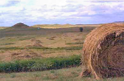
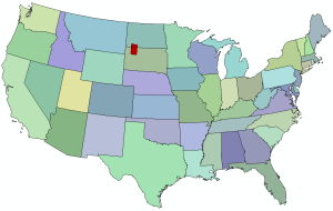 The Northern Great Plains, U.S. study area includes two adjacent counties in North and South
Dakota. Adams County, ND and Perkins County, SD, cover an area of 10,000 km2. Household data
at this site were collected in 1999. The area is sparsely populated, with a human population density
between 0.5 and 1 person/km2. The region is characterized as a temperate grassland ecosystem with
a unimodal precipitation pattern (summer precipitation). Average annual precipitation is 340 mm.
The region is exemplified by cold winters, short growing seasons, and large interannual fluctuations
in precipitation. Land use is dominated by extensive cattle operations and, where possible, dryland
wheat agriculture and petroleum exploration. Northern Great Plains agriculture is currently
experiencing a variety of stresses including, persistent climatic constraints and market, policy, and
social stresses, including a declining and aging population and decreasing social services. Many
farm operators have narrow profit margins, thus small changes in the climate or market can drive
them out of business. Often these farms are bought by corporations or large family
farms contributing to the regional trend of fewer, but larger, farms.
The Northern Great Plains, U.S. study area includes two adjacent counties in North and South
Dakota. Adams County, ND and Perkins County, SD, cover an area of 10,000 km2. Household data
at this site were collected in 1999. The area is sparsely populated, with a human population density
between 0.5 and 1 person/km2. The region is characterized as a temperate grassland ecosystem with
a unimodal precipitation pattern (summer precipitation). Average annual precipitation is 340 mm.
The region is exemplified by cold winters, short growing seasons, and large interannual fluctuations
in precipitation. Land use is dominated by extensive cattle operations and, where possible, dryland
wheat agriculture and petroleum exploration. Northern Great Plains agriculture is currently
experiencing a variety of stresses including, persistent climatic constraints and market, policy, and
social stresses, including a declining and aging population and decreasing social services. Many
farm operators have narrow profit margins, thus small changes in the climate or market can drive
them out of business. Often these farms are bought by corporations or large family
farms contributing to the regional trend of fewer, but larger, farms.