Global Litter Invertebrate
Decomposition Experiment
Manaus,
Brazil
Site Manager
Dr.
Heraldo Vasconcelos
Instituto de Biologia
Universidade Federal de Uberlandia
Campus Umuarama
CP 593
38400-902 Uberlandia, MG
Brazil
Telephone: (+092) 034 3 218 2243
Fax: (+092) 034 3 218 2243 ext. 35
Site Description
The Biological
Dynamics of Forest Fragments Project (BDFFP) is
a collaborative, bi-national project between the Smithsonian
Institution and the Brazilian Institute for Research
in the Amazon (INPA). Initiated in 1979, the research
station has conducted one of the only long-term projects
to evaluate the impacts of human activities in the
Amazon. The Project also promotes studies on basic
tropical ecology and areas related to forest regeneration,
and has invested heavily in training students and technicians
from Brazil and other Latin American countries. The
BDFFP mission is to determine the ecological consequence
of habitat destruction and fragmentation in the Amazon,
and to disseminate this information widely in such
a way as to foster conservation and ration use of forest
resources.
Site
Location
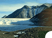
The BDFFP study
area is located ca. 80 km north of Manaus, Brazil (2°25'S,
60° W) within the Distrito Agropecuário.
Site
Area
The Distrito
Agropecuário is an area of approximately 500,000
ha of relatively undisturbed forest that is being developed
by the Manaus Trade-Free Zone (Suframa). Included in
the BDFFP are over 3,500 ha of forest reserves, ranging
in size from 1 to 1000 ha, and spread over a 60 km
wide area.
Site
Elevation
Site elevation is 80 -120 m.
Annual Rainfall
Precipitation averages around
2600 mm annually and varies seasonally with a rainy season
between November and May, and a dry season from June
and October.
Annual Temperature
Mean annual temperature is 27.6°C.
Soil
Soils are relatively nutrient-poor,
sandy or yellow latosols (xanthic ferralsols).
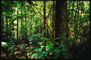
Native Forest/Vegetation
Types
The forest in the area is
typical terra firme forest (not subject to periodic flooding)
with a canopy height of 30-37 m. Species richness of
trees is high, averaging about 280 species per hectare.
The understory is relatively open and dominated by palms.
The site is located on pleistocenic terraces of interglacial
origin and the topography is ondulated with mean altitudinal
differences between plateaus and stream valleys of 40-50
m.
Principal
Biome/Ecoregion
Ecoregion is tropical moist forest.
Photo Gallery
|