


August 30, 2016
By Cara Steger
For two weeks in July 2016, I visited the Ethiopian highlands to initiate a collaborative research project with local community members living around a common property resource area. After two days of character-building bus rides and one nasty case of intestinal parasites, I arrived at Guassa Community Conservation area in the North Shoa zone of the Amhara region.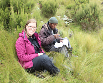 This high-altitude (3200 to 3700m asl) Afro-alpine moorland is named after four species of Fetusca grass (guassa grass) that are highly valued by local people for their use as thatch, rope, construction material, and grazing land. It is also, incidentally, one of the most beautiful places I have ever seen.
Though the Guassa area (roughly 100km2) has been managed by the people living around it for nearly 400 years, changing political administrations at both local and national levels have resulted in a significantly different modern governance arrangement from the traditional Qero system that occurred before the advent of the 1974 Communist regime. The area is now managed by nine kebeles (the smallest administrative unit in Ethiopia), each consisting of approximately 5,000 people. Each kebele contributes five people to the Guassa Council, plus one more to sit on the Tourism Board – which basically operates as the Executive Committee for all management issues in the area.
The purpose of my trip was to meet and talk with as many of these 45,000 people as I could, and I must say I did a pretty good job! My trip coincided with two large meetings where I was able to introduce myself and explain how I wanted my PhD research to align with their management needs. In order to design a research agenda that fulfilled both our needs, I first wanted to learn about the changes that have been occurring both within and around Guassa in recent years. People were happy to oblige, sitting and talking with me, my fiancé cum research assistant Geoff Burmeister, and my translator Girma Nigussie for hours.
One of the most memorable conversations we had was on the very first day while visiting kebele hiya (also known as Yedi). After my introduction to the 100+ group of village leaders, who seemed slightly bemused but enthusiastic about my proposed collaboration, we escaped from the freezing rain and mist into a local tea house.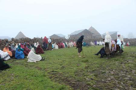 We were soon joined by a continuously changing group of men, women, and children who were attracted by both the novelty of the researchers and the mix of hot, spiced tea and strong, locally distilled ariki (corn liquor).
The conversation flowed more smoothly than you might expect when back-and-forth translation is necessary, and I learned a great deal about how people made their livelihoods in this challenging economic and ecological environment. Most people subsist off of their own barley (and sometimes wheat), grow beans for consumption and sale, and raise predominantly sheep and a few cattle. However, diversification is growing in the area as the German non-profit Frankfurt Zoological Society invests in things like modern beehives and apple seedlings, and as increased tourism to the area requires additional local guides and guards. However, these benefits are only available to the four kebeles adjacent to the Guassa area, leaving the five farthest kebeles without additional sources of income.
One of the first things that struck me about people’s descriptions of Guassa was how very different it sounded from the highly detailed journal article on Guassa governance published in 2005 by Dr. Zelealem Tefera Ashenafi (Ashenafi and Leader-Williams, 2005). Indeed, there were notable differences even from the brief visit I made to the area in May 2014. 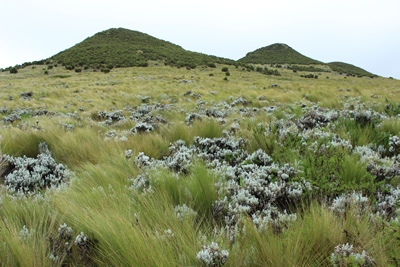 This area is obviously experiencing rapid change in both natural resources and the social systems used to manage them, and I sincerely hope that the proposed collaborative research will help them reflect upon these changes and prepare for future ones.
I repeated these sentiments later that week when I was invited to attend the Guassa Council and Tourism Board meeting taking place in the woreda capital of Mehal Meda, 22km away from Guassa. Though I saw many nods throughout the room, I also encountered a number of puzzled looks. As an often-overlooked rural community, it seems that people are not used to being consulted by foreign researchers, and finally they asked me to give them some time to consider what kind of research they might be interested in. I plan to return in October to conduct participatory mapping exercises describing land cover change in the area over the past 10-20 years, and I expect these workshops will inspire many conversations about the history and future of Guassa.
Finally, I should mention that this trip was only possible due to a generous contribution from The Rufford Foundation, a UK-based organization that funds conservation projects in developing countries. In addition to the small grant I received, Rufford connects project teams with others in the network, and provides a website for dissemination of project results and findings. You can find mine at: http://www.rufford.org/projects/cara_steger. Stay tuned for more updates over the next few months!