Our Study Areas
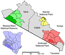
 The geographic focus for this proposal, three conservation areas in Kajiado and Narok Districts of Kenya, provide a unique
opportunity to study how a grazing animal responds to different levels of fragmentation and vegetation productivity. Within 250 km (155 miles) of
each other, the areas are similar in their ecology and contain migratory wildebeest, but have different levels of fragmentation.
Our study areas span a range of productivity, which in these semi-arid areas is closely tied to precipitation.
Precipitation ranges from about 400 mm per year (15.7 inches) in southeastern Kajiado to more than 1200 mm (47 inches) in parts of Narok.
The region has two wet seasons (short and long), and precipitation is vary variable from year to year.
The region was once communal lands. The Group Lands Representative Act of 1968 began a process of subdivision that continues. Narok and Kajiado Districts were subdivided into group ranches. During subdivision powerful members received individual parcels of land. That process was sanctioned by the government, and today most group ranches are fully subdivided, with ranch members owning small (e.g., 25 ha or 61 acres) parcels of land. More detail on the conservation areas and their surrounding private lands follows.
Nairobi National Park and the Athi-Kaputiei Plains
(Maps and project photos from the area)The Athi-Kaputiei Plains (2456 km2) are framed by the metropolis of Nairobi to the north, the Rift Valley to the west, brush lands on rough terrain to the south, and the Lukenya Hills and large colonial-era ranches to the east, some of which are fenced. At its northern extent is Nairobi National Park, the only one in the world that abuts a capital city. Nairobi National Park maintains populations of a variety of wildlife, which attract an average of 100,000 visitors each year. The park is fenced on its northern, eastern, and western boundaries. Migratory wildebeest and zebra move into Nairobi National Park as the dry season deepens in July, drawn to the rivers and dams that provide permanent water. When the rains return in October, the migrants move south into the Kitengela dispersal area and the Athi-Kaputiei Plains. Fragmentation south of the park has severely reduced migration, and wildlife populations have declined 72% from 1977 to 2002. Human land use in the Kitengela dispersal area and Athi-Kaputiei Plains is primarily livestock grazing - 80% of ungulate biomass is livestock - but includes cultivation, quarries, settlements, and an Export Processing Zone. Human populations have grown rapidly. Reid and others mapped fenced areas in the Athi-Kaputiei Plains in 2004, and the image is striking.
Maasai Mara National Reserve and Mara Ecosystem
(Maps and project photos from the area)The Mara Ecosystem (6000 km2) is the northernmost third of the much larger Serengeti-Mara Ecosystem (25,000 km2), home to the most diverse herds of migrating ungulates in the world. The ecosystem is bounded on the west by the Siria Escarpment, on the north by the forested Mau Uplands, to the east by the Loita Hills, with the Serengeti part of the ecosystem in Tanzania to the south. The Mara Ecosystem includes several group ranches and former group ranches that have converted to private land ownership, plus the Maasai Mara National Reserve that lies adjacent to the Tanzanian border and Serengeti National Park. Two large wildebeest migrations occur here, one a smaller population that migrates between the Mara Reserve and the Loita Plains to the north (our focus here) and the much larger migration of wildebeest that migrate from the Serengeti shortgrass plains in the south to the Mara. Both populations migrate to the Mara in the dry season and mingle, using the savanna both inside the Mara Reserve and the group ranches and private lands adjacent to the Mara. The group ranches outside Maasai Mara National Reserve are mostly intact, but large swaths have been converted to large-scale cultivation, and fencing is increasing, particularly as land becomes subdivided into private plots.
Amboseli National Park and the Amboseli Ecosystem
(Maps and project photos from the area)Amboseli Ecosystem (8000 km2) is in the rain shadow of Mount Kilimanjaro, and receives 350-500 mm yr-1 precipitation, with high variability between years. Wetlands replenished by runoff from Kilimanjaro provide permanent water and ample low quality forage. Amboseli National Park contains seasonal Lake Amboseli, grasslands and brushlands. Near the center of the park are acacia woodlands, which are fenced to prevent elephant damage. The park supports wildebeest, zebra, elephants, and a wide variety of other wildlife, and had 120,000 visitors in 2006. During the wet season, wildlife move out into the dispersal area that spans Kajiado and Longido in northeastern Tanzania; we will confine our study area to the higher density wildlife dispersal area (3000 km2) within Kajiado District, which is wholly in Kenya. Maasai group ranches surround Amboseli National Park. Diversification of livelihoods has been important for Maasai, but livestock raising remains the dominant livelihood. The park conserved the western wetlands, but the eastern wetlands are in group ranches and are now mostly subdivided for small-scale cultivation. Almost all the group ranches have voted to subdivide, and some are already divided, but the xeric ranches have not subdivided or are partially subdivided, and fences are uncommon.


